 | ColvilleNational Forest - Washington |
featured in
 | Washington Pocket Maps | |
 | National Forests Northwest |
location
maps

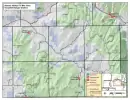
Map of Colville National Forest (West) in the USFS Pacific Northwest Region 06 in Washington. Published by the U.S. Forest Service (USFS).

Map of Colville National Forest (East) in the USFS Pacific Northwest Region 06 in Washington. Published by the U.S. Forest Service (USFS).

Map of the Tonasket Ranger District (West) of Colville National Forest in the USFS Pacific Northwest Region 6 in Washington. Published by the U.S. Forest Service (USFS).

Map of the Tonasket Ranger District (East) of Colville National Forest in the USFS Pacific Northwest Region 6 in Washington. Published by the U.S. Forest Service (USFS).

Map of the Republic Ranger District of Colville National Forest in the USFS Pacific Northwest Region 6 in Washington. Published by the U.S. Forest Service (USFS).

Map of the Three Rivers Ranger District (West) of Colville National Forest in the USFS Pacific Northwest Region 6 in Washington. Published by the U.S. Forest Service (USFS).

Map of the Three Rivers Ranger District (East) of Colville National Forest in the USFS Pacific Northwest Region 6 in Washington. Published by the U.S. Forest Service (USFS).

Map of the Sullivan Lake Ranger District of Colville National Forest in the USFS Pacific Northwest Region 6 in Washington. Published by the U.S. Forest Service (USFS).

Map of the Sullivan Newport District of Colville National Forest in the USFS Pacific Northwest Region 6 in Washington. Published by the U.S. Forest Service (USFS).

Map of Radar Dome and Mill Creek Sno-Parks Groomed Trail System in Washington. Published by Washington State Parks (WASP).

Map Little Pend Oreille Forest and Vicinity Trail System in Little Pend Oreille Forest in Washington. Published by Washington State Department of Natural Resources (WSDNR).

Forest User's Map of Republic/Three Rivers Ranger Districts (RD) of Colville National Forest (NF) in Washington. Published by the U.S. Forest Service (USFS).

Forest User's Map of Three Rivers Ranger District (RD) of Colville National Forest (NF) in Washington. Published by the U.S. Forest Service (USFS).

Forest User's Map of Sullivan/Newport/Three Rivers Ranger Districts (RD) of Colville National Forest (NF) in Washington. Published by the U.S. Forest Service (USFS).

Forest User's Map of Newport/Three Rivers Ranger Districts (RD) of Colville National Forest (NF) in Washington. Published by the U.S. Forest Service (USFS).

Motor Vehicle Use Map (MVUM) of Northeast Area of Colville National Forest (NF) in Washington. Published by the U.S. Forest Service (USFS).

Motor Vehicle Use Map (MVUM) of Northwest Area of Colville National Forest (NF) in Washington. Published by the U.S. Forest Service (USFS).

Motor Vehicle Use Map (MVUM) of Southeast Area of Colville National Forest (NF) in Washington. Published by the U.S. Forest Service (USFS).

Motor Vehicle Use Map (MVUM) of Southwest Area of Colville National Forest (NF) in Washington. Published by the U.S. Forest Service (USFS).

Map of Albian Hill Sno-Park Groomed Trail System in Washington. Published by Washington State Parks (WASP).

Map of Deer Creek Noridc Sno-Park Groomed Trail System in Washington. Published by Washington State Parks (WASP).

Motor Vehicle Use Map (MVUM) of the Kaniksu Zone (Back) of Idaho Panhandle Flathead National Forest (NF) in Idaho. Published by the U.S. Forest Service (USFS).

Recreation Map of Chopaka Lake and Chopaka Mountain Wilderness Study Area (WSA) in the BLM Wenatchee Field Office area in Washington. Published by the Bureau of Land Management (BLM).

Recreation Map of Palmer Mountain and Split Rock Recreation Sites (RS) in the BLM Wenatchee Field Office area in Washington. Published by the Bureau of Land Management (BLM).

Map of Bonaparte Sno-Park Groomed Trail System in Washington. Published by Washington State Parks (WASP).

Map of Scatter Creek Sno-Park Groomed Trail System in Washington. Published by Washington State Parks (WASP).

Map of Kings Lake Sno-Park Groomed Trail System in Washington. Published by Washington State Parks (WASP).

Map of South Summit Sno-Park Groomed Trail System in Washington. Published by Washington State Parks (WASP).

Map of North Summit Sno-Park Groomed Trail System in Washington. Published by Washington State Parks (WASP).

Map of Peacock Meadows Sno-Park Groomed Trail System in Washington. Published by Washington State Parks (WASP).

Map of Yellowjacket Sno-Park Groomed Trail System in Washington. Published by Washington State Parks (WASP).

Map of Antilon Lake Sno-Park Groomed Trail System in Washington. Published by Washington State Parks (WASP).

Map of Calispell Peak Area, North Fork Chewelah Creek Sno-Park Groomed Trail System in Washington. Published by Washington State Parks (WASP).

Map of Ninebark, Flowery Trail Sno-Parks Groomed Trail System published by Washington State Parks (WASP).

Map of the Chelan Ranger District of Okanogan-Wenatchee National Forest in the USFS Pacific Northwest Region 6 in Washington. Published by the U.S. Forest Service (USFS).

Map of the Methow Valley Ranger District of Okanogan-Wenatchee National Forest in the USFS Pacific Northwest Region 6 in Washington. Published by the U.S. Forest Service (USFS).

Map of the Entiat Ranger District of Okanogan-Wenatchee National Forest in the USFS Pacific Northwest Region 6 in Washington. Published by the U.S. Forest Service (USFS).

Map of the Wenatchee River Ranger District of Okanogan-Wenatchee National Forest in the USFS Pacific Northwest Region 6 in Washington. Published by the U.S. Forest Service (USFS).

Map of Okanogan-Wenatchee National Forest in the USFS Pacific Northwest Region 06 in Washington. Published by the U.S. Forest Service (USFS).

Recreation Map of the Mill Pond area in Colville National Forest (NF) in Washington. Published by the U.S. Forest Service (USFS).

Map of Mount Hull Off-Highway Vehilce (OHV) Trails in Tonasket Ranger District (RD) in Colville National Forest (NF) in Washington. Published by the U.S. Forest Service (USFS).

Map of Bannon Mountain Off-Highway Vehilce (OHV) Trails in Tonasket Ranger District (RD) in Colville National Forest (NF) in Washington. Published by the U.S. Forest Service (USFS).

Recreation Map of Fives Lakes area in Tonasket Ranger District (RD) in Colville National Forest (NF) in Washington. Published by the U.S. Forest Service (USFS).

Recreation Map of Conconully and Tiffany areas in Tonasket Ranger District (RD) in Colville National Forest (NF) in Washington. Published by the U.S. Forest Service (USFS).

Recreation Map of Pasayte Wilderness in Tonasket Ranger District (RD) in Colville National Forest (NF) in Washington. Published by the U.S. Forest Service (USFS).
Recreation Map of Aeneas Valley / Fir Mountain area in Tonasket Ranger District (RD) in Colville National Forest (NF) in Washington. Published by the U.S. Forest Service (USFS).

Map of Conconully Off-Highway Vehilce (OHV) Trails in Tonasket Ranger District (RD) in Colville National Forest (NF) in Washington. Published by the U.S. Forest Service (USFS).

Map with Points of Interests at Sherman Loop in Colville National Forest (NF) in Washington. Published by the U.S. Forest Service (USFS).

Draft of the Motor Vehicle Travel Map (MVTM) of Tonasket Ranger District in Okanogan-Wenatchee National Forest (NF) in Washington. Published by the U.S. Forest Service (USFS).

Draft of the Motor Vehicle Travel Map (MVTM) of Methow Valley Ranger District in Okanogan-Wenatchee National Forest (NF) in Washington. Published by the U.S. Forest Service (USFS).

Draft of the Motor Vehicle Travel Map (MVTM) of Chelan Ranger District in Okanogan-Wenatchee National Forest (NF) in Washington. Published by the U.S. Forest Service (USFS).

Map of Washington State Highways / Tourist Map. Published by the Washington State Department of Transportation (WSDOT).

Map of the western part of Coeur d'Alene River Ranger District of Idaho Panhandle National Forests in the USFS Northern Region 01 in Idaho, Montana and Washington. Published by the U.S. Forest Service (USFS).

Map of the southern part of Sandpoint Ranger District of Idaho Panhandle National Forests in the USFS Northern Region 01 in Idaho, Montana and Washington. Published by the U.S. Forest Service (USFS).

Map of the Bonners Ferry Ranger District of Idaho Panhandle National Forests in the USFS Northern Region 01 in Idaho, Montana and Washington. Published by the U.S. Forest Service (USFS).

Map of the Priest Lake Ranger District of Idaho Panhandle National Forests in the USFS Northern Region 01 in Idaho, Montana and Washington. Published by the U.S. Forest Service (USFS).

Map of Idaho Panhandle National Forests in the USFS Northern Region 01 in Idaho. Published by the U.S. Forest Service (USFS).


