 | BonaparteSno-Park - Washington |
featured in
 | Washington Pocket Maps |
location
maps

Map of Scatter Creek Sno-Park Groomed Trail System in Washington. Published by Washington State Parks (WASP).

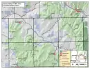
Map of Bonaparte Sno-Park Groomed Trail System in Washington. Published by Washington State Parks (WASP).

Official Visitor Map of Lake Roosevelt National Recreation Area (NRA) in Washington. Published by the National Park Service (NPS).

1:100K map of Oroville in Washington. Published by the U.S. Forest Service (USFS).

1:100K map of Republic in Washington. Published by the U.S. Forest Service (USFS).

Map of the Republic Ranger District of Colville National Forest in the USFS Pacific Northwest Region 6 in Washington. Published by the U.S. Forest Service (USFS).

Map of the Tonasket Ranger District (East) of Colville National Forest in the USFS Pacific Northwest Region 6 in Washington. Published by the U.S. Forest Service (USFS).

Map of Colville National Forest (West) in the USFS Pacific Northwest Region 06 in Washington. Published by the U.S. Forest Service (USFS).

Map of Mount Hull Off-Highway Vehilce (OHV) Trails in Tonasket Ranger District (RD) in Colville National Forest (NF) in Washington. Published by the U.S. Forest Service (USFS).

Map of Bannon Mountain Off-Highway Vehilce (OHV) Trails in Tonasket Ranger District (RD) in Colville National Forest (NF) in Washington. Published by the U.S. Forest Service (USFS).

Recreation Map of Fives Lakes area in Tonasket Ranger District (RD) in Colville National Forest (NF) in Washington. Published by the U.S. Forest Service (USFS).
Recreation Map of Aeneas Valley / Fir Mountain area in Tonasket Ranger District (RD) in Colville National Forest (NF) in Washington. Published by the U.S. Forest Service (USFS).

Map with Points of Interests at Sherman Loop in Colville National Forest (NF) in Washington. Published by the U.S. Forest Service (USFS).

Forest User's Map of Republic/Three Rivers Ranger Districts (RD) of Colville National Forest (NF) in Washington. Published by the U.S. Forest Service (USFS).

Draft of the Motor Vehicle Travel Map (MVTM) of Tonasket Ranger District in Okanogan-Wenatchee National Forest (NF) in Washington. Published by the U.S. Forest Service (USFS).

Map of Washington State Highways / Tourist Map. Published by the Washington State Department of Transportation (WSDOT).


