"Lifeguard Station" by U.S. National Park Service , public domain
Gulf Islands
National Seashore - FL,MS
Gulf Islands National Seashore offers recreation opportunities and preserves natural and historic resources along the Gulf of Mexico barrier islands of Florida and Mississippi. The protected regions include mainland areas and parts of seven islands
The Florida District of the seashore features offshore barrier islands with sparkling white quartz sand beaches (along miles of undeveloped land), historic fortifications, and nature trails. Mainland features near Pensacola, Florida, include the Naval Live Oaks Reservation, beaches, and military forts.
The Mississippi District of the seashore features natural beaches, historic sites, wildlife sanctuaries, islands accessible only by boat, bayous, nature trails, picnic areas, and campgrounds.
Detail of Davis Bayou of the official visitor map of Gulf Islands National Seashore (NS) in Florida and Mississippi. Published by the National Park Service (NPS).
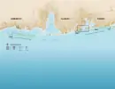
Detail of Pensacola Bay of the official visitor map of Gulf Islands National Seashore (NS) in Florida and Mississippi. Published by the National Park Service (NPS).
https://www.nps.gov/guis/index.htm
https://en.wikipedia.org/wiki/Gulf_Islands_National_Seashore
Gulf Islands National Seashore offers recreation opportunities and preserves natural and historic resources along the Gulf of Mexico barrier islands of Florida and Mississippi. The protected regions include mainland areas and parts of seven islands
The Florida District of the seashore features offshore barrier islands with sparkling white quartz sand beaches (along miles of undeveloped land), historic fortifications, and nature trails. Mainland features near Pensacola, Florida, include the Naval Live Oaks Reservation, beaches, and military forts.
The Mississippi District of the seashore features natural beaches, historic sites, wildlife sanctuaries, islands accessible only by boat, bayous, nature trails, picnic areas, and campgrounds.
Millions of visitors are drawn to the Gulf of America for Gulf Islands National Seashore's emerald coast waters, magnificent white beaches, fertile marshes and historical landscapes. Come explore with us today!
Gulf Islands National Seashore is a place of myriad riches - blue-green, sparkling waters, magnificent white beaches, and fertile coastal marshes. Its 13 areas include historic forts, shaded picnic areas, trails, and campgrounds. From Cat Island, Mississippi, it stretches eastward 160 miles tot he Okaloosa Area east of For Walton Beach, Florida.
Fort Barrancas Visitor Center
The Fort Barrancas Visitor Center tells the long history of European settlers attempts to secure the vital Pensacola Bay beginning in the late 1700s and through its deactivation in the mid-1900s.
The Fort Barrancas Area is on Taylor Road approximately a half mile east from the Museum of Naval Aviation. The area includes the historic Water Battery, Fort Barrancas, trails, visitor center, picnic areas, and the Advanced Redoubt. Visitors may access the Fort Barrancas via the main gate entrance to the Pensacola Naval Air Station.
Fort Pickens Visitor Center
Explore indoor exhibits on the natural environment, wildlife, and history of the Fort Pickens Area inside the Visitor Center.
Enter Fort Pickens Area drive to the end of Fort Pickens Road.
William M. Colmer Visitor Center
Located in the Davis Bayou area of Gulf Islands National Seashore this is the main visitor center for the park resources in Mississippi.
The entrance to the park's Davis Bayou area is located off of U.S. Highway 90, accessible via exits 50 or 57 on I-10.
Davis Bayou Campground
Gulf Islands National Seashore's Davis Bayou Campground offers tent and recreational vehicle camping experiences in a wooded area next to Davis Bayou in Mississippi. Campground office hours are 8 am to 4 pm Tuesday through Saturday.
Davis Bayou Campground Site
22.00
There is a standard year round rate for each of the campsites within the Davis Bayou Campground. Senior pass holders are eligible for a 50% discount on nightly fees.
Davis Bayou Campground Group Camping (10-25 campers)
20.00
The group camping area at the Davis Bayou Campground can accommodate groups for a single nightly rate.
Davis Bayou Campground Group Camping (26-40 campers)
30.00
The group camping area at the Davis Bayou Campground can accommodate groups for a single nightly rate.
Davis Bayou Campground
Sunlight shines through the trees onto an RV and car at a campsite.
Sunny campground at Davis Bayou
Davis Bayou Campground Dog
A dog and owner sit in front of a campfire at their RV site.
A dog and owner at Davis Bayou campground
Fire ring and picnic table
picnic table
A fire ring and picnic table for the campground rv spot.
Davis Bayou Campground Restroom
Exterior of a building
Gender neutral campground restroom
Amenity 1 Boat Launch
Parking lot
Boat launch
Amenity 2 Fishing Pier
Wood path
Davis Bayou Fishing Pier (license required)
Davis Bayou Trail
Wood trail
Davis Bayou boardwalk trail along Hanley Road
Davis Bayou Group Campground
The area is available with a permit for a minimum of 10 and a maximum of 40 occupants. Persons camping in the group area are limited to the restroom facilities located at pavilion #5. Parking is limited.
Davis Bayou Campground
Two people in a campground
Two people walk in the campground
Campground fire ring and picnic table
Fire ring and picnic table
Fire ring and picnic table
Fort Pickens Campground
The Fort Pickens Campground is one of the top ten busiest campgrounds in all of the 430+ national parks and sites. Available all year round it provides access to white sandy beaches and trails, including the Florida National Scenic Trail. The campground office is located in a historic white building located halfway down Fort Pickens Areas on Fort Pickens Road. Office hours are 10 a.m. to 3 p.m. Checkout by 11 a.m. Check-in begins at 2 p.m.
Entrance Fee
25.00
An additional fee to enter the National Park is required to be purchased separately.
Fort Pickens Campground Loop E
A road bisects a grassy campground with RVs and cars.
Fort Pickens Campground Loop E
Fort Pickens Tent Camping
The sun sets on a small tent set up in the grass near a small road.
Tent camping can be an excellent experience at Fort Pickens.
Florida Trail
A trail bridge leads to a gravel trail leading into the distance between trees.
Access trails directly from your campsite.
Florida Trail at Campground Loops B-E
A sign for the Florida National Scenic Trail stands in front of a campground loop.
Florida Trail at Campground Loops B-E
Fort Pickens Campground Restrooms
The sun reflects off of a concrete structure with four shower entrances.
Fort Pickens Campground has restrooms, showers, and coin operated laundry services.
Fort Pickens Campground Loop E Restrooms
A concrete restroom stands in a campground.
Fort Pickens Campground Loop E Restrooms
Loop A Overflow Parking
A sign for overflow parking stands in the bushes with a gravel parking lot beside.
Overflow Parking at Campground Loop A
Fort Pickens Campground Loops D-E
Several empty grass campsites with picnic tables and pavement stand in a row.
Fort Pickens Campground Loops D-E
Fort Pickens Campground Loop A
A row of empty campsites stands with a tree in the foreground.
Fort Pickens Campground Loop A
Fort Pickens Campground Loop A
A road bisects a campground with trees lining the sides.
Fort Pickens Campground Loop A
Tent Camping at Fort Pickens
Tents and picnic tables under the trees at Fort Pickens.
Tent Camping at Fort Pickens
Fort Pickens Group Campground
Group site is available with a permit for a minimum of 10 and a maximum of 40 occupants. Campground limited to soft-side on-the-ground tents only. Group area does not allow generators, trailers, pickup campers, RVs or any type of camping equipment. Persons camping in the group area are limited to the facilities (showers and restrooms) in the group area only. Entrance fee still applies.
Naval Live Oaks Youth Group Camping
This area is available reservation throughout the year with a permit for organized youth groups comprised primarily of young people under the age of 18. This group camping area is located near Gulf Breeze, Florida and has direct access to Pensacola Bay for water recreation. The campsite features restrooms, outdoor showers, a picnic shelter, and a campfire ring. The Naval Live Oaks Area has over 7.5 miles of trails for campers to explore. To make a reservation email guis_special_use_permits@nps.gov.
Naval Live Oaks Youth Group Camping (10-25 campers)
20.00
The group camping area at the Naval Live Oaks Youth Group Campsite can accommodate groups for a single nightly rate.
Naval Live Oaks Youth Group Camping (26-40 campers)
30.00
The group camping area at the Naval Live Oaks Youth Group Campsite can accommodate groups for a single nightly rate.
Campfire Ring
Wooden benches surround the campfire ring a the Naval Live Oaks Youth Campground.
Wooden benches surround the campfire ring a the Naval Live Oaks Youth Campground.
What a View!
A wooden bench sets below trees at the edge of the water
The youth campground is right on the bay.
Restrooms and Outdoor Showers
A brick building with restrooms on either side.
The youth campground has flush toilet restrooms and outdoor showers.
Pavilion
Picnic tables sit under a shaded pavilion.
The youth campground features a large picnic pavilion, perfect for gathering the whole group beneath for meals or activities.
Pensacola Bay City Ferry in Florida
Ferry in the Pensacola Bay
A National Park Service ferry navigates the Pensacola Bay to Fort Pickens.
Fort Barrancas and Spanish Water Battery
A white building and a fort
Fort Barrancas and Spanish Water Battery sit on Naval Air Station Pensacola.
Fort Massachusetts
A fort with water on an island
Fort Massachusetts sits on Ship Island in the Gulf off Mississippi.
Santa Rosa Area
White sand and green water
The Santa Rosa Area is the stech of beach between Navarre and Pensacola Beach. There is a fee area called Opal Beach.
Naval Live Oaks Area
Green trees with water
The maritime forest sits on the Santa Rosa Sound in the Naval Live Oaks Area, fee free area in Gulf Breeze, Florida.
Davis Bayou
Water
Davis Bayou is a fee free area in Ocean Springs, Mississippi. Home to beautiful nature area.
Perdido Key Area
Wood boardwalk to a sound water.
Perdido Key Area is a fee area featuring 7 crossovers, 2 pavilions, and 4 parking lots on the Gulf and Sound.
Fort Pickens
A fort
Fort Pickens is the most visited site in the Florida District.
The First Bombardment of Pensacola Bay
On the morning of November 22, 1861, a Union cannon inside Fort Pickens broke the sound of crashing waves and cawing gulls. More cannon on Santa Rosa Island soon joined in the effort to destroy the Confederates across the bay. Confederate cannon inside forts McRee and Barrancas, and more than a dozen earthen sand batteries, soon returned fire. The fighting continued until after sunset when a thunderstorm swept through the area.
Historic engraving showing a birds-eye view of the bombardment of Pensacola Bay in 1861.
The Second Bombardment of Pensacola Bay
Civil war engulfed the United States by January 1862. East and west of the Appalachian Mountains, Union and Confederate forces dotted the landscape, ready to march and fight. In northwest Florida, Union and Confederate soldiers welcomed the New Year engaged in a fierce bombardment that warned of hardships and sacrifices for both the North and the South.
Four panel historic engraving showing several scenes from a bombardment in different locations.
Florida Secession
As President of Florida’s secession convention, John C. McGehee believed remaining in the Union meant allowing rule by those who were "sectional, irresponsible to us, and driven on by an infuriated fanatical madness that defies all opposition" and who would "destroy every vestige of right growing out of property in slaves."
A newspaper clipping announcing Florida's secession from the Union in 1861.
Mississippi Secession
Mississippi seceded from the United States on January 9, 1861. In doing so, members of the state’s secession convention felt it their duty to tell the world why. "Our position is thoroughly identified with the institution of slavery--the greatest material interest of the world," members declared. Most members saw secession as necessary to protect and continue slavery, the source of white wealth, identity, and values.
Black and white image of the old Mississippi state house.
Shark Awareness
Before heading into the ocean, review some safety information to further minimize the chances of a shark encounter.
Shark and fish in the blue ocean waters
Gulf Islands Wildland Fire Collaboration
Gulf Islands Wildland Fire Collaboration
Battery Langdon
During WWII as the threat of Japanese and German naval encroachment increased, Battery Langdon’s guns were enclosed in concrete casemates with walls 10 feet thick and 17 feet of overhead masonry to protect them from incoming projectiles
Battery Langdon
Battery Pensacola
Battery Pensacola's position in Fort Pickens shows a contrast between the old brick and the more modern concrete batteries-- in Battery Pensacola the bricks are black.
Battery Pensacola
Battery Cooper
This battery is camouflaged by and earthen bunker making it invisible looking at it from the waters of the Gulf of Mexico.
Battery Cooper
Battery Payne
With Battery Trueman to the north, the guns from both of these batteries covered as 360 degree field of fire.
Battery Payne
Replacement of Waysides at Davis Bayou & Ship Island
In 2017, this project provided for the replacement 52 wayside exhibits in the Mississippi areas of the park including, 22 on Ship Island and 30 at the Davis Bayou Area.
Two sun-damaged wayside panels lean against frames holding the new panels.
Replacement of Lifesaving Station Windows
This 2013 project replace the 36 windows at the historic Lifesaving Station with new historically accurate windows to protect the historic structure.
Red roofed building with a small parking lot.
Fort Pickens Restroom Facility
This 2018 project replaced the outdated restroom facility at historic Fort Pickens with a new accessible restroom at the Fort Pickens Mine Storeroom area.
Concrete restroom structure under construction.
Pensacola Bay Cruises Tour Boat Videos
To enhance the rider experience aboard the tour boats, this 2017 project developed three interpretive videos.
A tour boat docked at a concrete pier with a black railing.
Permanent Message Reader Boards
This 2018 project provided funding for remotely operated permanent variable message boards at the park.
A electronic message board stands next to a roadway.
Johnson Beach Lifeguard Tower
This 2017 project funded the replacement of the Perdido Key, Johnson Beach Lifeguard tower.
A lifeguard tower stands on a beach.
Davis Bayou Campground Restrooms
This 2012 project replaced the outdated and in extremely poor condition restroom facility at the Davis Bayou Campground with a fully accessible facility including restrooms and showers.
Exceeding Expectations
During the fight for freedom, African American soldiers were forced to deal with discrimination on a regular basis. For no other reason than possessing a different skin color, these men were perceived to be inferior troops. Yet over several fierce fights, men such as the Louisiana Native Guard proved their worth.
Photo of African American soldier
Emancipation and the Quest for Freedom
Although the abolition of slavery emerged as a dominant objective of the Union war effort, most Northerners embraced abolition as a practical measure rather than a moral cause. The war resolved legally and constitutionally the single most important moral question that afflicted the nascent republic, an issue that prevented the country from coalescing around a shared vision of freedom, equality, morality, and nationhood.
Slave family seated in front of their house
Uncrewed Aircraft Assists with Research at Gulf Islands National Seashore
In September 2014, an unmanned aircraft was used to photograph an area of Gulf Islands National Seashore known as The Camille Cut.
A man holds a small fixed wing aircraft above his head.
Campground Loops A, C, & B-D Restrooms
These projects, funded in 2013, 2015, & 2017, replaced the old inefficient, outdated, and inaccessible restroom facilities at the Fort Pickens Campground.
A concrete restroom building with trees and scrub brush surrounding.
Ruddy Turnstone
The ruddy turnstone is often seen alongside the larger Willet and the smaller Sandpiper along the shores of Gulf Islands.
Ruddy Turnstone
25th United States Colored Troops: The Sable Sons of Uncle Abe
During the Civil War, men of African descent fought to preserve the nation they helped create and extend freedom to enslaved people. Black infantrymen in the 25th United States Colored Troops (USCT) carried freedom's banner into northwest Florida. From Pensacola Bay, the 25th helped save the Union, end slavery, and prepare for a new future.
Historic poster reading "Men of Color, To Arms! To Arms! Now or Never"
Racoon
With black masks that make them looks like bandits, raccoons are always an interesting species to watch.
A raccoon peering around a tree
Golden Silk Orb Weaver
These spiders are also sometimes referred to as banana spiders.
Golden silk orb weaver on a web
Killdeer
If not seen the killdeer can be heard with a high pitched call: ="kill-deer," for which the bird is named for.
Killdeer out in the open
Willet
Larger than your average shorebird
Willet on the shore
Mine Storeroom Adaptive Reuse
Several minor projects in 2017 and 2018 related to the restoration of the building were funded through the fee program.
New concrete pathways are poured in the foreground of two brick buildings.
Environmental Assessment to Reconfigure Visitor Parking and Beach Access at Perdido Key Area
Thanks to funding provided through entrance fees in 2015, the park was able to complete this critical step allowing for a scope of work to be developed so the park can obtain additional funding to implement the planned redesign.
Engineering Report on Fort Pickens Area Water Systems
This 2016 project provided the park with an engineering report to guide the replacement of this outdated and inefficient systems.
Historic Structure Reports
These projects, funded by your fee dollars, created Historic Structure Reports which lay the foundation for the National Park Service to preserve the historic structures in its care.
Davis Bayou Picnic Area Restrooms
This 2015 project replaced the restroom facility in the Davis Bayou Picnic Area.
The Fort Pickens Parley
A high-stakes meeting took place outside Fort Pickens three months before the start of the Civil War. Four men—William H. Chase, Ebenezer Farrand, Jeremiah H. Gilman, and Adam J. Slemmer—met to negotiate for the fort. The meeting's outcome would decide who controlled the most powerful fort on Pensacola Bay and one of the most important ports in the United States.
A historic engraving of men meeting on a dock.
Beach Morning-glory
Beach morning-glory's beautiful white blooms can be seen growing in the white sands at Gulf Islands.
Beach Morning-glory
Common Nighthawk
Common nighthawks can be identified while they are flying by their white patches out past the bend of each wing.
A common nighthawk flying
Eastern Ribbon Snake
Often mistaken for a garter snake, the eastern ribbon snake is much more slender.
Eastern Ribbon Snake
Battery Worth
Completed in 1899, Battery Worth is located northeast of Battery Cooper on Santa Rosa Island.
Battery Worth
Carolina Anole
This green anole is the only native species of anole in the United States.
Carolina Anole
Preserving Places of Captivity: Civil War Military Prisons in the National Parks
During the Civil War, over 400,000 Union and Confederate soldiers were held prisoner at more than 150 diff erent prison sites. Approximately 56,000 of these died in captivity. Although Andersonville is the most famous Civil War prison, it is only one of many Civil War military prisons that are preserved by the National Park Service.
False Rosemary
With beautiful purple flowers, false rosemary is a member of the mint family.
False Rosemary
Preservation of Batteries Cullum-Sevier
Closed to all public access for many years due to the unsafe conditions, Batteries Cullum-Sevier preservation has begun. Some portions of the 1920s additions have collapsed and water intrusion has caused the steel reinforcements to corrode, which has significantly weakened the concrete structure. There is a long road ahead which will require funding, but the park service is committed to preserving and providing access to this historic site in the coming years.
Concrete crumbles from an elevated position.
Second Louisiana Native Guard
Organized in October of 1862, the 2nd Louisiana Native Guards was mustered into service and initially all but one of the company officers were considered men of color. Colonel Nathan Daniels was in command and the enlisted men signed up for three years of infantry service. Recruits varied in age from 17 to 56 and in experience including skilled tradesmen like cigar makers, masons, coopers, printers, slaters, and engineers.
Black and white image of African American soldiers formed on a beach.
Andrew Jackson in Pensacola, Florida
Andrew Jackson may not have been present in Pensacola often, but his presence is an important part of this city’s legacy. Jackson was assigned to Pensacola three times, once in 1812, then in 1818, and lastly in 1821 and each time his actions were in favor of American freedoms, authority, and sovereignty. Though not every decision Jackson made while in Pensacola was well received, each experience impacted his future and the future of this country.
A pencil sketch of soldiers marching into a city, an officer is on horseback in the center.
2014 Sea Turtle Annual Report Cape Hatteras
2014 annual report on sea turtle monitoring at Cape Hatteras National Seashore.
Green sea turtle returning to sea after laying her eggs.
Andrew Jackson Trail
The first major federal highway in Florida.
White sand path cutting through green trees and plants. A bright sun in a blue sky.
Third System of Coastal Forts
How should a country protect its borders? The United States had to consider this question when the War of 1812 ended in 1815. One year later, the federal government believed it had an answer. The nation created a broad national defense strategy that included a new generation of waterfront defenses called the Third System of Coastal Fortifications.
The setting sun lights a stone fort wall where a US flag flies high.
The Battle of Santa Rosa Island
The air on Pensacola Bay was tense in October 1861. In September, Union sailors and marines destroyed the Judah, a Confederate ship under modification at the Pensacola Navy Yard. Now, Union and Confederate forces waited for the next battle to explode in a growing civil war.
A map of the Battle of Santa Rosa Island.
Yaupon Holly
This shrub’s bright berries and dense branches provide food and shelter for birds and mammals. Learn more on our quick facts page.
Red berries on green-leafed shrub branches against a blue sky.
Stingray
Stingrays have eyes on top of their bodies and mouths on the underside. To catch prey, stingrays rely on smell and electroreceptors. Learn more on our quick facts page.
Dark grey stingray buried in the sand underwater.
Beach Segregation
We all love spending a warm day on a beautiful beach. However, there was a time when public beaches were not open to all to enjoy. Public beaches, like many other public facilities such as schools, swimming pools, theaters, and restaurants, were segregated. This segregation came in the form of local and state laws, as well as, “understood” social norms. Collectively these laws and social norms were known as Jim Crow.
Green vegetation grows on a white sand beach, blue-green water extends into the distance.
Fort Pickens Ordnance Shop
The foundation of these buildings can still be seen standing in the center of the Fort Pickens Historic District just to the northwest of historic fort access road.
Aerial black and white photo of several buildings scattered across a sandy landscape.
Battery 233
Constructed during World War II, this battery on Perdido Key was never armed or named, but dominates the landscape today.
A black line sketch of a defensive battery floor plan with many features identified.
US Life-Saving Service
The United States Life-Saving Service (USLSS), the predecessor to the United States Coast Guard, formed in 1878. The story of the USLSS dates to almost 100 years before the service became an official agency, to the noble efforts of the Humane Society of the Commonwealth of Massachusetts, a group of affluent individuals seeking to prevent needless deaths from shipwrecks.
A black and white photo of seven men wearing uniforms and standing in front of a boat house.
Black Racer
Young black racers do not resemble adults and are generally tan or grey with brown or red patches running down the center of the back.
A black and white snake sticks out a black tongue.
Coyotes
As members of the dog family, coyotes can be identified by their narrow snout, small nose pad, and large ears relative to their head size.
A light and dark brown coyote in a grassy field.
Gulf Fritillary
Gulf Fritillary's can often be seen fluttering around passionflower vines.
Gulf Fritillary
Battery Trueman
Battery Trueman and Battery Payne worked together to protect the Pensacola Harbor
3-inch rapid-fire gun atop Battery Trueman
Battery Van Swearingen
The threat of war with Spain prompted the immediate construction of this battery in 1898.
Van Swearingen
Seacoast Ordnance
Cannon manufactured for use in Third System forts are called seacoast ordnance. These were some of the largest and heaviest cannon available at the time. Cannon at forts Pickens, McRee, Barrancas, Massachusetts, and Advanced Redoubt fell into three categories: guns, howitzers, and mortars. Each had a specific purpose.
Nutria
This invasive species can be found on the national seashore's barrier islands in Mississippi.
A brown rodent surrounded by green vegetation.
Documentation of the historic Battery 234 Tower
This project allowed the park the park fully documented the tower through the Heritage Documentation Programs (HDP), specifically the Historic American Engineering Record (HAER) prior to the removal of the observation booth. As part of the documentation, the tower was scanned with photogrammetry in order to get a detailed 3D picture of the state and condition of the tower before it is dismantled.
A heat map where color represents height; the image shows a observation tower.
Battery Worth Picnic Pavilion Accessibility Improvements
Project replaced approximately 1,085 square feet of deteriorated, crumbling and raised edge concrete with new, level ADA concrete walkways to include four ADA compliant grill pads and two outdoor shower pads. The new sidewalks, grill pads, and showers permit visitors a solid, accessible path.
An open-air brick pavilion stands in the distance with showers in the foreground.
Cottonmouth
The only aquatic viper in the world, also referred to as a water moccasin. Learn more on our quickfacts page.
Brown scaled snake with a large, open, white mouth exposing fangs.
Battery Center
The first concrete battery constructed on the eastern end of Perdido Key, this four-cannon battery helped protect Pensacola Bay into the early 1900s.
Black and white image of a barrier island with two low concrete structures surrounded by a seawall.
Live Oak Tree
Known as “live oaks” for their ever-green properties, the Q. virginiana is native to the southern region of the United States. The live oak is known for its impressive size, heartiness, and density.
Mississippi Quarantine Stations
Port cities during the late 1800s and early 1900s were alive with activity. Global trade made these towns sickly places as travelers arrived after long trips at sea. To combat this, many sea-faring ports created quarantine rules for protection from disease. Off the coast of Mississippi, barrier islands were used to house quarantine stations.
Passengers disembark from a small vessel at the US Quarantine Station.
Chemical Warfare Station on Horn Island
The Chemical Warfare Service Quarantine Station on Horn Island was a project by the US Army to test toxic weapons during WWII. Poisonous warfare has a long history, dating back to at least 600 BCE. In its modern use, weapons using deadly chemicals have destroyed thousands of lives.
Newspaper clipping describing the destruction of mustard gas bombs on Horn Island.
Japanese Americans on Cat Island
In late 1942, the US Army selected Nisei (second generation Japanese Americans) from the 100th Infantry Battalion to take part in a top-secret training mission. Whisked away under secrecy, the soldiers traveled to Ship Island, Mississippi. Ray Nosaka, one of the selected Nisei, noted that the group did whatever they wanted for the first two weeks until “Major Lovell came and told us that we are going to train dogs and it’s located on Cat Island.”
25th United States Colored Troops: 1864 Muster Roll
During the Civil War, several regiments of the USCT served within the park boundaries. We have few details of the men who served at the forts in our museum collection. But one object in the collection, a muster roll from 1864, has valuable information: names!
Opal Beach Security Doors Replacement
The Opal Beach restrooms are year-round facilities used by park visitors. The original security overhead doors no longer worked, preventing the park from securing the restrooms. This project completely replaced the six damaged overhead doors and their hardware.
A concrete building with a pull-down, grill gate, across the doorway opening.
Civil War Along the Gulf Coast
The United States' Gulf Coast is steeped in Civil War history and memory. Scattered among the beaches and bays, bayous and rivers, forests and farms, are some of the most important sites related to a conflict that defined a nation.
A historic engraving of the Battle of Mobile Bay, ships engaged with a coastal fort.
Fort Pickens Group Camping Restroom Replacement
This project replaced the existing comfort station at the Fort Pickens Group Camping area which was failing and did not meet current accessibility requirements or visitor needs. The new comfort station installed as part of this project four stalls of which all are ADA.
A crane lifts a pre-constructed building into place in a sandy area.
Davis Bayou Boat Ramp Replacement
This project completely rebuilt the public boat launch at the Davis Bayou Area of the national seashore.
Narrow piers extend into water, marsh and woodland areas are seen in the background.
Lionfish
Lionfish have no known predators in non-native waters, making them highly invasive.
A scuba diver in blue ocean water looks at a red and white striped fish.
Batteries Cullum and Sevier
Battery Sevier was formed by the separation of Battery Cullum into two batteries
Batteries Cullum and Servier
American Kestrel
North America’s smallest falcon species. Learn more on our quick facts page.
Black, white, and brown feathered Kestrel perched in a tree.
Coachwhip
Non-venomous snake slithering during the day. Learn more on our quick facts page.
Black/brown scaled coachwhip in a tree.
North American Bald Eagle
A symbol of freedom and strength, the majestic bald eagle was officially adopted as the emblem of the United States in 1787. Learn more on our quickfacts page.
A brown and white feathered bald eagle perched in a tree.
Sanderling
A speedy little member of the sandpiper family. Learn more on our quick facts page.
Small, white and grey sanderling running from the waves on a beach.
Field Moment: Gulf Island National Seashore; 19 October 2014, 1:12 a.m.; Turtle T.H.i.S.
Youth volunteers help conserve sea turtles at Gulf Islands National Seashore
Youth volunteers measure nighttime ambient light conditions at Gulf Islands National Seashore
NPS Geodiversity Atlas—Gulf Islands National Seashore, Florida and Mississippi
Each park-specific page in the NPS Geodiversity Atlas provides basic information on the significant geologic features and processes occurring in the park.
sandy beach
Changing Patterns of Water Availability May Change Vegetation Composition in US National Parks
Across the US, changes in water availability are altering which plants grow where. These changes are evident at a broad scale. But not all areas experience the same climate in the same way, even within the boundaries of a single national park. A new dataset gives park managers a valuable tool for understanding why vegetation has changed and how it might change in the future under different climate-change scenarios.
Green, orange, and dead grey junipers in red soil, mountains in background
Women in Fire Science: Alicia Schlarb
Alicia Schlarb is the lead fire effects monitor for a portion of the National Park Service's Southeast Region. She and her crew provide prescribed burning, monitoring, and wildland fire responses to national parks located within Mississippi, Louisiana, Alabama, and portions of Tennessee, Kentucky, and Florida. She loves fire and that she can change perceptions about wildland fire through science.
Alicia Schlarb.
Regina P. Jones Underwood Brake
Regina Jones-Brake's career with the National Park Service (NPS) began in 1976 with the bicentennial of the Declaration of Independence. Over the next 33 years, her love of American history compelled her to share untold stories as she advanced from park ranger to management assistant.
Regina Jones-Underwood pictured outdoors in her NPS uniform.
Paleontology in the Parks Fellowships: A New Collaborative Program between the Paleontological Society and the National Park Service
Dr. Christy Visaggi and her students Michael Clinton and Megan Rich are conducting pilot projects at Gulf Islands National Seashore and Vicksburg National Military Park for the joint National Park Service–Paleontological Society Paleontology in the Parks Fellowship Program.
photo of 2 people sitting in an off road vehicle on a beach
Series: Park Paleontology News - Vol. 14, No. 1, Spring 2022
All across the park system, scientists, rangers, and interpreters are engaged in the important work of studying, protecting, and sharing our rich fossil heritage. <a href="https://www.nps.gov/subjects/fossils/newsletters.htm">Park Paleontology news</a> provides a close up look at the important work of caring for these irreplaceable resources. <ul><li>Contribute to Park Paleontology News by contacting the <a href="https://www.nps.gov/common/utilities/sendmail/sendemail.cfm?o=5D8CD5B898DDBB8387BA1DBBFD02A8AE4FBD489F4FF88B9049&r=/subjects/geoscientistsinparks/photo-galleries.htm">newsletter editor</a></li><li>Learn more about <a href="https://www.nps.gov/subjects/fossils/">Fossils & Paleontology</a> </li><li>Celebrate <a href="https://www.nps.gov/subjects/fossilday/">National Fossil Day</a> with events across the nation</li></ul>
photo of 2 people kneeling in shallow water at the base of a steep slope
Battle of the Bark
Trees shade us from the sun, provide homes for wildlife, stabilize Earth’s surface, and produce food for humans and animals alike. Some are massive, and others are miniscule by comparison, but what makes one better than the other—we’ll let you decide! Check out our iconic trees below and find your favorite!
Five thick barked red-brown trees are backlit by the sunlight.
Coastal Geohazards—Storm Surges
Storm surge may severely impact coastal geomorphology and inundate park resources. Brought by coastal storms, storm surge can be dangerous and have lasting effects. Coastal areas that remain at low elevation are prone to the effects of storm surge. The magnitude of a storm surge is increased when coupled with sea level rise.
damaged road with sand overwash
Series: Coastal Geohazards
Natural processes such as tsunamis, coastal landslides, and storms are driving forces of change along the coast. These processes and other coastal hazards can threaten parks’ cultural and natural resources, infrastructure, and public recreational opportunities.
storm surge waves breaking over pathway
Helping Islands Stay on a “Budget”
National island parks in the Gulf of Mexico are hemorrhaging sand at an increasing rate. Here's how we slow the bleeding.
Man in NPS uniform climbs onto a damaged seaside road from the ocean side
50 Nifty Finds #11: Carving a Place in NPS History
Few employees have left as visible a mark on National Park Service (NPS) exhibits as John A. Segeren. His work has been enjoyed by generations of park visitors who never knew his name but appreciated his intricate wood carvings and playful animal figures displayed in parks throughout the system. A master woodcarver described by former President Lyndon B. Johnson as "a legacy to this country," Segeren carved out his own place in NPS history.
Round wooden plaque with bison, globe, and waterfall
Outside Science (inside parks): Teens & Turtles
When sea turtles hatch in areas with lots of light pollution, they can get disoriented and not make it into the ocean. This episode tracks the young volunteers in the Pensacola, FL area working to help turtle hatchlings make it to the sea.
Sea turtles
Updated Species Database Will Help Boost Amphibian Conservation Across the National Park Service
To steward amphibians effectively, managers need basic information about which species live in parks. But species lists need constant maintenance to remain accurate. Due to recent efforts, the National Park Service now has an up-to-date amphibian species checklist for almost 300 parks. This information can serve as the basis for innumerable conservation efforts across the nation.
A toad sits on red sand, looking into the camera.
Guide to the National Parks Conservation Association (NPCA) Southeast Region Collection
This finding aid describes the National Parks Conservation Association (NPCA) Southest Region Collection, part of the NPS History Collection.
The Shipwreck Tagging Archaeological Management Program (STAMP)
Climate change compels National Park archeologists to use science to save valuable data from deteriorating and disappearing back into the sea. In response, the National Park Service’s Submerged Resources Center (SRC) and its partners are expanding their shipwrecking timber tracking initiative, the Shipwreck Tagging Archaeological Management Program (STAMP), to encompass all national parks with bodies of water.
Person attaching a tag to a timber
Disaster evaded: proof from the Pudding Fire
In 2024, firefighters discovered evidence of a lightning-caused fire at Gulf Islands National Seashore. Dubbed the Pudding Fire, it had been naturally suppressed in an area where extensive mechanical fuel reduction and prescribed fire had taken place.
Three men stand on or near a skid-steer in a recently cleared corridor in thick vegetation.
Coastal Dynamics Monitoring at Gulf Islands National Seashore, Mississippi and Florida: 2018-2024
Summary of findings from coastal dynamics monitoring at Gulf Islands National Seashore in Mississippi and Florida from 2018 to 2024. This article presents how the park has changed in terms of dune topography and shoreline position over the past several years for Horn Island, Petit Bois Island, West Petit Bois Island, Fort Pickens, and Perdido Key.
View of the shoreline on Horn Island, MS
Amphibian Monitoring at Gulf Islands National Seashore: Two-Year Summary through March 2024
Two-year summary of findings from amphibian monitoring in Naval Live Oaks Area of Gulf Islands National Seashore, near Pensacola, Florida. Treefrogs and other amphibians are monitored at two sites near freshwater ponds using PVC pipes and plywood coverboards. Amphibian community composition and changes in the relative abundance of common species are tracked over time as indicators of park ecological health.
a green treefrog viewed head-on
“Cracking the code” on mercury bioaccumulation
Read the abstract and get the link to a published paper on a model to predict mercury risk park waterbodies: Kotalik, C.J. et al. 2025. Ecosystem drivers of freshwater mercury bioaccumulation are context-dependent: insights from continental-scale modeling. Environmental Science & Technology. DOI: 10.1021/acs.est.4c07280
A person stands in a field looking at a bug through a magnifying lens.
Sharing the shore with birds
Each year, beginning in February and ending in late summer, the Gulf Islands National Seashore provides an important habitat for several species of ground-nesting shorebirds including, least terns, snowy plovers, Wilson’s plovers, and black skimmers.
Black and white bird with two eggs in sand.
Shaping the Southeastern Park Experience: How Monitoring Plant Communities Makes a Difference
NPS scientists and staff work together to protect park vegetation and the ecosystems it supports. From prescribed burns in pine savannas to invasive species removal in coastal forests, many management actions begin with one thing: science-based knowledge of what’s changing and why. To facilitate understanding, scientists from the NPS Inventory & Monitoring (I&M) Division conduct long-term vegetation monitoring in more than 40 parks across the Southeast.
A ranger speaks to a group of children, pointing to something on a tree trunk.
Rooted in the Southeast: Learning from Plants in Familiar Places
Southeastern national parks inspire millions of visitors each year as places to recreate and learn about the region’s culture and history, contributing to local economies. Yet alone, these parks cannot take care of themselves. Preserving parks for the public’s long-term enjoyment requires careful stewardship, active management, along with sound scientific understanding. This is achieved through NPS’s long-term vegetation monitoring programs.
A ranger indicates something offscreen to a group of children surrounded by pines and saw palmettos.
Southeastern Plants: Ecosystem Anchors Under Threat
Long-term monitoring of plant community condition supports the National Park Service mission to preserve natural resources unimpaired for future generations. By detecting ecological trends and stressors—such as invasive species expansion, habitat degradation, and climate-induced shifts—scientists provide park managers with actionable data to guide adaptive management and maintain ecosystem resilience.
A waterfall surrounded by vibrant fall foliage.
Series: Long-Term Vegetation Monitoring in Southeastern Parks
The National Park Service’s mission is to protect and preserve natural resources for present and future generations. In the Southeastern U.S., treasured resources in parks include time-worn mountains, white sand beaches, and several biodiversity hotspots. Protecting these resources requires careful, ongoing science. This series describes how long-term vegetation monitoring data are collected and used to guide management decisions so that parks and surrounding communities continue to thrive.
A scientists uses a hand lens to peer up-close at small pink flowers in a grassy area.
My Park Story: Karli Reeves
At Indiana Dunes National Park, recent Let's Go Birding intern Karli Reeves helped design programs and activities to make the park experience more accessible.
A young woman wearing a blue shirt with binoculars hanging around her neck
Gulf Islands
National Seashore
Florida, Mississippi
National Park Service
U.S. Department of the Interior
Fort Pickens
“...as the means of preserving peace, and as obstacles to an
invader, their influence and power are immense.”
- Lt. Henry W. Halleck “Report on the Means of National Defense” 1843
Coastal Defense
For over a century, Fort Pickens guarded the entrance to the Pensacola Bay Harbor and the Navy
Shipyard, protecting the American coastline from foreign invasion. The fort has withstood the
actions of war, time, and the elements. Named after Revolutionary War hero General Andrew
Pickens, the fort was the largest of the four forts built in this area.
General Andrew Pickens
Construction
Army drawing of
Fort Pickens
Civil War
Fort Pickens bombarding
Forts McRee and Barrancas
Defense Through
the 1900s
Modern batteries were added
in and around the fort.
During the War of 1812, vulnerabilities along America’s shores were exploited by British forces.
In response, the United States constructed a system of over 40 coastal forts. These forts could
withstand cannon balls fired from wooden ships. Fort Pickens is an enduring monument to a time
in American history when our independence and national security were dependent upon the brick
and mortar of our seacoast fortifications.
Designed for over 200 cannon, built with over 21.5 million bricks and completed in 1834, Fort
Pickens was a formidable structure and a war machine. Built in the shape of a pentagon, the fort
could withstand possible attack on all five faces; landward on the east side and seaward on the other
four. Its four-foot thick walls and symmetrical archways were built to endure heavy cannon fire.
Construction began in 1829 under the supervision of the U.S. Army Corps of Engineers. Due to
the lack of skilled laborers in the area, the government allowed contractors to use slave labor. Up to
200 enslaved masons, carpenters, and laborers of African descent were working at any given time.
Those working on the fort were exposed to disease, intense heat, and high humidity. Following the
completion of Fort Pickens, many of these slaves went on to build Forts McRee and Barrancas.
Although built to repel foreign invaders, the only combat that took place at the fort was during the
American Civil War. In October 1861, General Braxton Bragg led 1,000 Confederate soldiers in a
land assault against Union forces encamped outside the fort. Following the Battle of Santa Rosa
Island, Union forces bombarded Forts McRee and Barrancas from land and sea on November 2223, 1861, and again on January 1-2, 1862. All three forts sustained some damage, but Fort McRee
and the navy yard were nearly destroyed. Confederates abandoned Pensacola in May 1862. Fort
Pickens saw no further combat, and the fort remained in Union control throughout the war.
To keep up with advances in technology, Fort Pickens underwent dramatic changes after the
Civil War as part of a larger system of upgrading American defenses. New batteries were added,
smoothbore cannon were replaced or converted to rifled cannon, and equipment to lay and
maintain an underwater minefield in the harbor was installed. The most notable addition is Battery
Pensacola, constructed in 1898. Painted black to reduce glare from sand and water, it covers most
of the parade ground, and is one of many reinforced concrete batteries built on the island. Learn
more on the Coastal Artillery self-guiding tour.
Preservation
Fort Pickens was an integral part of the United States’ coastal defense system until 1947 when
coastal forts were declared surplus. Formerly a state park, in 1971, Fort Pickens became part of Gulf
Islands National Seashore, which preserves the structure and tells the fort’s history. Today, Fort
Pickens represents a link between our past, present and future.
Fort Pickens visitor center and museum are open daily. For more information about visiting the
fort, and a current listing of ranger-led programs, please visit our website at nps.gov/guis, like us on
Facebook - Facebook.com/GulfIslandsNPS, or call 850-934-2600.
The National Park Service turns 100 in 2016. Celebrate the Centennial with us with programs and
activities throughout the year. Learn, discover, be inspired, or simply have fun at Gulf Islands!
Guide to Fort Pickens
Take a stroll through
history to see how Fort
Pickens was designed to
oppose enemy forces from
the early 1800s through
1947. As you wander, be
careful of uneven sandy
surfaces and steps and low
doorways. To preserve our
history, practice “Leave
No Trace” principles and
Pack-it-in, Pack-it-out.
1.Sallyport: Secured with heavy oak doors, this
is the main entrance to the fort. The word “sally”
means to rush forth. Tracks were later installed
to move heavy equipment and ammunition to
Battery Pensacola.
9 & 10. Counterscarp, Moat, & Bastions:
The counterscarp created a ditch, or dry moat,
on the other to protect the fort from land-based
assaults. Attackers who reached the dry moat
Gulf Islands
National Seashore
Florida, Mississippi
National Park Service
U.S. Department of the Interior
Fort Barrancas
Situated on the bluffs overlooking Pensacola Bay, Fort Barrancas was built to
protect the United States from foreign invaders. Once considered vital to national
defense, today Fort Barrancas illustrates the evolution of military technology and
American values.
Building the Fort
1839-1844
After Spain’s cession of Florida to the United
States in 1819, the U.S. Army Corps of Engineers
dispatched officers to survey the new coastline.
The U.S. Navy selected Pensacola Bay to become
the site of its main navy yard on the Gulf Coast.
In order to protect the navy yard and the bay, the
U.S. Army built permanent coastal fortifications.
Built between 1839 and 1844, Fort Barrancas
was the third fort established on the bay. It was
constructed over the ruins of a 1798 Spanish fort
named Fort San Carlos de Barrancas. Situated
below the barrancas (Spanish for bluffs) was
a 1797 water battery named Bateria de San
Antonio. The water battery was retained and
modified for use by the Army.
The Civil War
1861-1865
When Abraham Lincoln became president-elect
in November 1860, Southern slaveholding states
began seceding or talked of seceding from the
Union. A national crisis had begun.
On January 8, 1861, 1st Lieutenant Adam
Slemmer ordered Company G, 1st U.S. Artillery
to guard Fort Barrancas to prevent its seizure
by Florida. On January 10, Slemmer evacuated
the mainland forts in favor of Fort Pickens. That
same day Florida seceded from the Union.
Forts Barrancas and McRee, Advanced Redoubt,
and the navy yard were occupied by Florida and
Alabama militia on January 12. Fort Barrancas
was used to organize and train Confederate
soldiers. These soldiers used the fort’s cannon
U.S. Coastal Defense
1885-1947
Fort Barrancas became obsolete because of new
developments to cannon and naval war vessels.
In 1885 the U.S. government began evaluating
proposals for new coastal defenses, and an 1893
survey deemed Pensacola Bay commercially and
militarily important.
In 1902 Fort Barrancas was equipped with a Fire
Commander’s Station and general secondary
stations to help direct artillery fire from Santa
The planned armament for the fort included:
ten 24-pounders (pdrs); two 8-inch seacoast
howitzers; five 18-pdrs; three 12-pdrs; one
8-inch mortar; two coehorn mortars; two field
6-pdrs and one field 12-pdr; and eight 24-pdr
flank howitzers in the counterscarp. The water
battery included eleven 32-pdrs; two 8-inch
seacoast howitzers; and two 10-inch mortars.
Major William H. Chase was the Army’s
Superintending Engineer. Chase contracted
a company to lease enslaved men to work
as laborers and tradesmen to build the fort.
From March 21 to September 21, the enslaved
labored from sunrise to sunset, with one hour
for both breakfast and dinner.
in a bombardment against Fort Pickens on
November 22 and 23, 1861. Confederate
Major General Braxton Bragg wrote: “For the
number and caliber of guns and weight of metal
brought into action it will rank with the heaviest
bombardment in the world.”
The Confederate army evacuated Pensacola in
May 1862. After sixteen months U.S. soldiers
reclaimed Fort Barrancas. Some regiments that
garrisoned the fort composed free and enslaved
black men. These regiments included the
14th Regiment, Corps d’Afrique, 25th United
States Colored Troops (USCT), 82nd USCT,
and the 97th USCT. Private George Mitchell
of Company G, 25th USCT, was a former slave
who fought for his freedom at Fort Barrancas.
Rosa Island and Perdido Key. By 1914 the fort
received a radio station and two steel masts.
The Coast Artillery Corps was responsible
for these defenses through World War II. Fort
Barrancas was declared surplus in 1947.
As military technology and American values
evolved, the mission for Fort Barrancas
remained the same – protect the bay and the
laws, principles, and lives of American citizens.
Guide to Fort
Barrancas
1. Glacis: This gentle earthen slope protected
the fort from land-based artillery while exposing
attacking infantrymen.
2. Scarp and Counterscarp: The main walls
(scarp) supported the barbette which provided
defense against both ships and infantry. The
outer walls (counterscarp) supported the
glacis and provided loopholes for muskets and
embrasures for cannon to fire into the ditch.
7. Scarp Gallery: A series of arches supported
the sand fill and allowed access to the loopholes
for muskets. Vertical vents above the loopholes
allowed smoke from the guns to escape.
8. Counterscarp Gallery: A tunnel under the
ditch leads to this casemated area, containing
loopholes for muskets, embrasures for cannon,
and powder magazines to allow reverse fire into
the ditch.
9. Parade: This open area is where troops
were inspected or drilled. The foundation in
the corner indicates where a hot shot furnace,
in which round shot was heated before firing,
once stood.
10. Water Battery: The tunnel from the parade
leads
Gulf Islands NS
National Park Service
U.S. Department of the Interior
Gulf Islands National Seashore
Florida District
Advanced Redoubt of Fort Barrancas
Why Redoubt?
The Advanced Redoubt of Fort Barrancas was built between 1845 and 1870 as
part of a defensive network for the Pensacola Navy Yard. Forts Pickens, McRee,
and Barrancas protected the entrance to the harbor; the Advanced Redoubt was
constructed to defend the northern side of the peninsula on which the navy yard
was located. On October 8, 1863, Confederate Brigadier General Clanton led
an attack against Fort Barrancas defended by U.S. Colored Troops of the 14th
Regiment Corps d’Afrique and the 7th Vermont Infantry. General Clanton was
heard to say that his men were after the blacks; “that he would not fire on the
white pickets, but that every black picket that could be seen would be shot.” After
a brisk skirmish the estimated 200 Confederates retired into the woods. The
next day the Confederates returned and engaged the pickets with musketry at
Advanced Redoubt. The Federals blazed back with small arms and a few howitzer
rounds. The Confederate troops retreated again with no casualties reported on
either side.
An Infantryman’s
Nightmare: Attack the
Redoubt
The design of the Advanced Redoubt (an
enclosed work protecting a strategic point),
exhibits the idea of defense in depth. As an
attack began to beat back the defenders,
the attacking soldiers would meet new
obstacles to their progress. The goal was to
make an assault as costly as possible and to
exhaust the attacking troops before they
could gain access to the fort and the
navy yard beyond. The modern visitor
approaches the Advanced Redoubt from
the east and south, coming first to the side
and rear of the fort. However, an enemy
would most likely have come from the west,
down the peninsula.
Touring the Redoubt
Step Back in Time
To appreciate the power of the fortress take a stroll through history to see how
the Advanced Redoubt was designed to oppose enemy forces. As you wander, be
careful of uneven walkways, dark areas, slippery places, and snakes.
#1. You are on an open slope called
the glacis. As an attacker, you would
be exposed to cannon and musket fire
from the main wall (scarp) as well as
musket fire from the top of the outer wall
(counterscarp). The solution is to dig a
series of trenches to cover the advance. The
trenches must be big enough for cannon as
well as infantry to advance.
#2. As a rush of infantry from the
trenches overwhelms the west end of the
counterscarp, defenders would fall back
to these traverses. Defending soldiers are
still protected, while the attackers are now
exposed. The two traverses allow the
defense to fall back gradually while offering
stubborn resistance.
Tradition and
Technology
caught in a deadly crossfire of musketry
while facing a hail of canister from the
howitzers. The brick-lined ditch is the
cunette, for drainage.
#4. If the enemy reaches the back of
the fort (the gorge), additional musket
fire would come from galleries atop the
demibastions on either side. (The pitting
visible today resulted from target practice
in the 1930s and 1940s.)
#5. Attackers might attempt to enter
the fort through the sallyport after first
destroying the drawbridge. On either side
are embrasures for howitzers, both atop
and within the demibastions. Here was the
deadliest crossfire of all.
#3. At the end of the moat are two
windows that have been sealed with red
brick. These are embrasures for cannon
called flank howitzers. Canister, cannonsized buckshot, would be fired down
the ditch. Notice the loopholes (vertical
windows in the wall) on either side.
Infantry could fire muskets through these
loopholes while completely protected by
the wall. Anyone in the moat would be
These forts could only be taken by means
of a siege. Weeks of trenching would bring
cannon up to point-blank range to pound
the walls with solid shot. Debris from
the collapsing walls would fill the moat
and give access to the fort’s interior. A
siege took a tremendous amount of time,
equipment, and casualties, and might
be broken at any time if reinforcements
arrived at the Redoubt.
The Advanced Redoubt was built at the
end of an era, incorporating the lessons of
many centuries of engineering. For over
500 years, cannon had hurled round iron
balls to batter down walls. Cannon had
ended the age of castles, and had led to the
designs found in seacoast forts like Pickens,
Barrancas, and Redoubt. Among the most
advanced of their day, these forts were built
to last for centuries.
Nevertheless the fort was completed
because engineers had not yet solved the
problems presented by the new weapons.
But the changes in technology that mark
the modern age had begun before the
Redoubt was completed. By the end of the
American Civil War in 1865, rifled cannon
and ironclad warships had made this fort,
and all others like it, obsolete.
The United States continues to struggle
with the need for protection. A
National Park Service
U. S. Department of Interior
Gulf Islands National Seashore
Coast Artillery
Self-guided Tour
Battery Cullum at the instant of firing, 1930
“It felt like the world was ending.” McHenry Harry, 1935
When Langdon’s guns went into action the vibrations could be felt all the
way to Pensacola across the bay. McHenry Harry recalled the first time he
pulled the lanyard, the cord which activated the firing mechanism: “It felt
like the world was ending.” His hat blew off, his pants split, and he could
see concussions rippling through the sand.
Homeland Security through World War II
Before the age of nuclear weapons, “homeland security” meant “harbor
defense.” In the absence of long-range airplanes, intercontinental
ballistic missiles, and amphibious assault equipment, any potential attack
on the U.S. (except from Canada or Mexico) required capturing
harbors to unload armies and supplies. Protecting the harbors protected
the entire country, and harbor defenses received our best technologies
and most powerful weapons.
The success of Fort McHenry in keeping the British fleet out of Baltimore
Harbor in the War of 1812 inspired the “Star-Spangled Banner” and the
building of castle-like forts to defend other harbors from 1817 to 1870.
For centuries, cannons fired round balls and ships were made of wood.
Against these threats, masonry forts like Pickens and Barrancas were
unbeatable. Simply building such forts at all major harbors effectively
closed them to foreign navies and the armies they might bring. But by the
end of the Civil War in 1865 all this had changed. Revolutionary
inventions including rifled cannon and ironclad warships had defeated
harbor defenses. New defenses were needed.
2 Coast Artillery Self-guided Tour
Underwater mine defenses (shown here about 1910) were used at
Pensacola from 1894 until 1926.
Protecting harbors against modern navies required new weapons and
tactics, and eventually a new branch of the U.S. Army, the Coast Artillery
Corps (CAC). The CAC used underwater mines, searchlights, complex
systems for tracking moving targets at sea, and huge guns in concrete
batteries. The threat of fast motorboats led to rapid-firing artillery,
airplanes led to anti-aircraft artillery, and every new naval threat was
countered by new defenses.
By the 1930’s, the job of defending Pensacola Bay fell to the 13th Coast
Artillery Regiment, headquartered at Fort Barrancas Army Post, on what
is now the western half of Pensacola Naval Air Station. A 10-minute ferry
ride took the men across the bay to Fort Pickens, where a smaller army
post area supported all of the active gun batteries. Summer
encampments housed Florida National Guard units and Reserve
Officers Training Corps (ROTC) students from The Citadel, University of
Alabama, Mississippi State, and Georgia Tech for weeks of training on
anti-aircraft and heavy artillery, and the complex science of tracking a
moving target across miles of featureless water by triangulation.
Once on the island, men assigned to outlying batteries boarded a
narrow-gauge train, dubbed the B&F for “back and forth” railroad, that
made the 3-mile run twice daily. A soldier missing the train had a tiring
hike through the soft island sand to his destination, watching for rattlesnakes. For the plotting crew, the triangulation tracking system required
coordinated spotting to the ringing of a 15- or 20-second time interval
bell, using precision optics, and doing complex calculations while
National Park Service 3
Dressed in dark blue denim fatigue
uniforms, artillerymen posed next
to a 12-inch artillery shell for
Battery Pensacola, circa 1910
under stress. Far greater hazards were encountered at gun drills. Guns
weighing as much as 58 tons, projectiles over 1000 lbs., and large amounts
of high explosives presented constant dangers. Even when everything
worked right, the concussion of firing the big guns could knock a man
breathless. Hearing problems were so common that the condition was
called “Artilleryman’s Ear.” When things went wrong, men were maimed
or killed.
Tensions were high after Pearl Harbor and German U-boats sank ships in
the Gulf of Mexico in 1942, but by 1943 the tide of war turned in favor of
the Allies. The last batteries built at Pickens and McRee were completed
that year, but never armed. New technologies of that war, including jet
airplanes, ballistic missiles, and the atomic bomb, made harbor defense
less important to homeland security.
Fort Pickens and the Fort Barrancas Army Post closed in 1947. Guns,
railroad tracks, and steel towers were salvaged, leaving only concrete
remains. Now gulls call and children play where powerful weapons once
shook the earth and stood ready to defend the country. Not long ago,
these concrete bunkers were vital to homeland defense. Their time has
passed even as the story continues, and new threats demand new defenses.
To learn more about harbor defense, tour the concrete batteries or read
The Soldiers Story: Th
Gulf Islands
National Park Service
U.S. Department of the Interior
Gulf Islands National Seashore
Florida District
Animal Checklist
The Wild in Wildlife
This animal checklist includes amphibians, reptiles and mammals observed
on the offshore islands, on the mainland and in the waters of Gulf Islands
National Seashore. These habitats provide resting, feeding and nesting areas
for a variety of wildlife. Federal laws protect all wild animals within the park.
Please keep wildlife Wild by not feeding or harassing them. Offering food is
unhealthy for the animal and potentially unsafe for you. An unrestrained pet
can harm wildlife and destroy their habitat, while possibly endangering the
pet. By protecting the park’s natural resources, the National Seashore will be
preserved for all to enjoy.
Key
Abundance
Status - Federal (F) & State (S)
Caution
A = Abundant
C = Common
U = Uncommon
R = Rare
T = Threatened
E = Endangered
SSC = Species of Special Concern
V = Venomous
Mammals
White-tailed Deer
Odocoileus virginianus R
Coyote
Canis latrans R
Common Gray Fox
Urocyon cinereoargenteus U
Red Fox
Velpes vulpes U
Bobcat
Lynx rufus R
Striped Skunk
Mephitis mephitis C
Northern River Otter
Lutra canadensis U
American Mink
Mustela vison R
Common Raccoon
Procyon lotor C
Black Bear
Urus americanus R
Short-finned Pilot Whale
Globicephala macrohynchus R
Atlantic Spotted Dolphin
Stenella frontalis R
Bottle-Nosed Dolphin
Tursiops truncatus C
Pygmy Sperm Whale
Kogia breviceps R
Sperm Whale
Physeter macrocephalus R
Brazilian Free-tailed Bat
Tadarida brasiliensis R
Big Brown Bat
Eptesicus fuscus U
Seminole Bat
Lasiurus seminolus C
Evening Bat
Nycticeius humeralis R
Virginia Opossum
Didelphis virginiana C
Eastern Mole
Scalopus aquaticus C
Swamp Rabbit
Sylvilagus aquaticus R
Eastern Cottontail
Sylvilagus floridanus U
American Beaver
Castor canadensis R
Nutria
Myocastor coypus C
House Mouse
Mus musculus U
Muskrat
Ondatra zibethicus R
Marsh Rice Rat
Oryzomys palustris U
Santa Rosa Beach Mouse
Peromyscus polionotus leucocephalus U
Perdido Key Beach Mouse
Peromyscus polionotus trissyllepsis R E(F & S)
Norway Rat
Nattus norvegicus C
Black Rat
Rattus rattus U
Hispid Cotton Rat
Sigmodon hispidus C
Southern Flying Squirrel
Glaucomys volans R
Eastern Gray Squirrel
Sciurus carolinensis C
Fox Squirrel
Sciurus niger R
Manatee
Trichechus manatus R E(F & S)
Nine-Banded Armadillo
Dasypus novemcinctus C
Reptiles
American Alligator
Alligator mississippiensis R SSC(S) T(F)
Eastern Glass Lizard
Ophisaurus ventralis C
Scarlet Snake
Cempphora coccinea R
Florida Scarlet Snake
Cemophora coccinea coccinea R
Eastern Racer
Columber constrictor A
Black-masked Racer
Columber constrictor latrunculus U
Southern Black Racer
Columber constrictor priapus C
Ring-necked Snake
Diadophis punctatus R
Corn Snake
Elaphe guttata guttata C SSC(S)
Eastern Rat Snake
Elaphe obsoleta C
Common Kingsnake
Lampropeltis getula U
Speckled Kingsnake
Lampropeltis getula holbrooki C
Coachwip
Masticophis flagellum flagellum C
Salt Marsh Water Snake
Nerodia clarkii U
Green Water Snake
Nerodia cyclopion C
Plainbelly Water Snake
Nerodia erythrogaster R
Southern Water Snake
Nerodia fasciata C
Banded Water Snake
Nerodia fasciata fasciata U
Florida Green Water Snake
Nerodia floridana U
Brown Water Snake
Nerodia taxispilota C
Rough Green Snake
Opheodrys aestivus C
Redbelly Snake
Storeria occipitomaculata R
Southeastern Crowned Snake
Tantilla coronata R
Eastern Ribbon Snake
Thamnophis sauritus sauritus C
Common Garter Snake
Thamnophis sirtalis C
Eastern Coral Snake
Micrurus fulvius fulvius C V
Mediterranean Gecko
Hemidactylus torcicus A
Southern Fence Lizard
Sceloporus undulatus vundulatus C
Green Anole
Anolis carolinenisi C
Southeastern Five-lined Skink
Eumeces inexpectatus A
Broadhead Skink
Eumeces laticeps C
Ground Skink
Scincella lateralis C
Six-Lined Racerunner
Cnemidophorus sexlineatus C
Cottonmouth
Agkistrodon piscivorus U V
Eastern Diamondback Rattleshake
Crotalus adamanteus C V
Pigmy Rattlesnake
Sistrurus miliarius C V
Carolina Pigmy Rattlesnake
sistrurus milarius miliarius U V
Loggerhead Sea Turtle
Caretta caretta C T(S & F)
Hawksbill Sea Turtle
Eretmochelys imbricata U
Green Sea Turtle
Chelonia mydas U E(S & F)
Kemp’s Ridley Sea Turtle
Lepidochelys kempii R E(F & S)
Snapping Turtle
Chelydra serpentina C
Alligator Snapping Turtle
Macroclemys temminckii U
Leatherback Sea Turtle
Dermochelys coriacea R E(F & S)
Yellow-bellied Slider
Trachemys scripta C
Chicken Turtle
Deirochelys reticularia U
Diamondback Terrapin
Malaclemys terrapin U
Common Cooter
Pseudemys floridana C
Eastern Box Turtle
Terrapene carolina U
Red-eared Slider
Trachemys scripta elegans C
Eastern Mud Turtle
Kinosternon subrubrum C
Gopher Tortoise
Gopherus polyphemus R SSC(S)
Amphibians
Oak Toad
Bufo quercicus C
Southern Toad
Bufo terrestris C
Southern Cricket Frog
Acris gryllus C
Green Treefrog
Hyla cinerea C
Pine Woods Treefrog
Hyla femoralis C
Barking Treefrog
Hyla gratiosa C
Squirrel Treefrog
Hyla squirella C
Gulf Islands
National Park Service
U.S. Department of the Interior
Gulf Islands National Seashore
Florida District
Barrier Island Wildflowers
Where they live
Gulf Islands National Seashore’s barrier islands are home to a large variety
of plants. The most noticeable are the wildflowers. Wildflowers are found
in different plant and animal communities. Each community has a particular
combination of environmental factors (soil type, light intensity, wind exposure
and moisture) that determines where certain plants live. Plants help hold sand
in place and provide food and shelter for animals. These plant and animal
communities are critical to the survival of the barrier islands. For this guide, the
following communities are used:
Dune Sand dunes up to 30 feet in height that are parallel to the Gulf of
Mexico and often continuous in appearance. Dunes are dry and
sandy. Includes areas adjacent to dunes. Primary dunes (P) are closest
the Gulf, secondary dunes (S) are behind primary dunes.
Swale -
Low, wetland areas with moist soil; may be flooded with rain water.
Forest -
Taller pines and oaks, shrubs and other plants grow in dry, sandy soil.
Marsh -
Contains standing freshwater (f), saltwater (s) or a mixture of both.
Disturbed - Areas altered by people, usually near roads and/or structures.
Plant type
Blue/Purple
Brown
Green
Unnoticeable
Color
Key
W - Woody, tree or shrub
V - Vine
H - Herbaceous,
green-stemmed plants
Type Common Name
Scientific Name
Flowering Season
Occurance by Habitat
Sp - Spring, Mar. - May
S - Summer, June - Aug.
F - Fall, Sept. - Nov.
W - Winter, Dec - Feb.
Main season(s) underlined
C = Common
U = Uncommon
R = Rare
Flowering Dune Swale Forest
season
Marsh
W
Florida Rosemary
Ceratiola ericoides
S F
C (S)
W
Beach Elder
Iva imbricata
S
C
H
Square Flower
Paronychia erecta
Sp S
C (S)
W
Sand Live Oak
Quercus geminata
Sp
U (S)
H
Hastate Leaf Dock
Rumex hastatulus
Sp
H
Sandspur
Cenchrus sp.
Sp S F
R (S)
H
Seaside Pennywort
Hydrocotyle bonariensis
Sp S F
U
H
Black Needle Rush
Juncus roemerianus
Sp S F
H
Saw Palmetto
Serenoa repens
Sp S
U (S)
V
Catbriar, Greenbriar
Smilax spp.
Sp S
U (S)
U
H
Cordgrass
Spartina patens
S
U (S)
U
V
Muscadine Grape
Vitis rotundifolia
Sp S
R (S)
H
Sawgrass
Cladium jamaicense
S
C (F) U (S)
H
Cattail
Typha domingensis
Sp S
C (F)
H
Sea Oats
Uniola paniculata
S
C
H
Scrub Mint
Conradina canescens
Sp
U (S)
C
V
Maypops
Passiflora incarnata
S
R (S)
R
H
Blue-eyed Grass
Sisyrinchium sp.
Sp
H
Spiderwort
Tradescantia sp.
Sp S
Disturbed
U
U
C
C
U
U
U
R
C
U
C
C (S)
R (S)
U
U
C
C (S)
C
U
U
U
U
C
R
C
Red Color
Yellow
Pink/Lavender
White
Type
Common Name
Scientific Name
Flowering
season
H
Standing Cypress
Ipomopsis rubra
S
H
Balduina, Yellow Buttons
Balduina angustifolia
F
V
Trumpet Creeper
Campsis radicans
S
W
Woody Goldenrod
Chrysoma pauciflosculosa
F
C (S)
U
H
Golden Aster
Chrysopsis sp.
F
C (S)
U
H
Coreopsis, Tickseed
Coreopsis spp.
Sp
H
Rockrose
Helianthemum arenicola
Sp S
C (S)
U
H
Camphorweed
Heterotheca subaxillaris
Sp S F W
C (S)
U
C
W
Atlantic St. John's Wort
Hypericum reductum
Sp S
U (S)
H
Seaside Evening Primrose
Oenothera humifusa
Sp S F
C
H
Prickly Pear Cactus
Opuntia humifusa
Opuntia pusilla
Sp S
R (S)
U
U
H
Narrow Leaf Ground Cherry
Physalis angustifolia
Sp S
U (S)
H
Candywort
Polygala lutea
Sp S F
U
U (F)
H
Yellow Milkwort
Polygala nana
Sp S F
U
U (F)
H
Bladderwort
Utricularia subulata
S
U
C
H
Yellow-eyed Grass
Xyris sp.
Sp S
C
H
False-foxglove, Gerardia
Agalinis sp.
F
U (S)
H
Sandhill Milkweed
Asclepias humistrata
S
U (S)
H
Sea Rocket
Cakile constricta
Sp S
C (P)
V
Butterfly Pea
Centrosema virginianum
Clitoria mariana
S
U
H
Dwarf Sundew
Drosera brevifolia
Sp
H
Beach Pea
Galactia sp.
S
V
Arrowleaf Morning Glory
Ipomoea sagittata
S
H
Salt Marsh Mallow
Kosteletzkya virginica
S
W
Lantana (non-native)
Lantana camara
Sp S F
C
W
Oleander (non-native)
Nerium oleander
Sp S F
U
H
Phlox (non-native)
Phlox drummondii
Sp S
C
H
Rose Pogonia
Pogonia ophioglossoides
Sp
R
H
Milkwort
Polygala brevifolia
S F
U
U
H
Meadow Beauty
Rhexia mariana
Sp S
C
U
H
Sea Pink
Sabatia spp.
S F
C
H
Sea Purslane
Sesuvium portulacastrum
Sp S F
H
Rain Lily
Zephyranthes sp.
Sp S F
U
H
Wild Onion
Allium canadense
Sp
C
W
Groundsel Tree
Baccharis halimifolia
S F
H
Spanish Needles
Bidens sp.
F
V
Dodder Vine
Cuscuta pentangona
Sp S F
H
White-topped Sedge
Dichromena latifolia
S
W
Yaupon Holly
Ilex vomitoria
Sp
C (S)
V
Beach Morning Glory
Ipomoea stolonifera
S
U (P)
H
Redroot
Lachnanthes caroliniana
S
C
U
H
Bog Buttons
Lachnocaulon minus
S
C
C
H
Jointweed
Polygonella gracilis
F
H
Rustweed
Polypremum procumbens
Sp S F
V
Dewberry
Rubus trivialis
Sp S
H
Gulf Islands
National Park Service
U.S. Department of the Interior
Gulf Islands National Seashore
Florida District
Apache Prisoners at Fort Pickens
Photo credit Pensacola Historical Society
Fort Pickens as a Prison
for Apaches
On the morning of October 25, 1886 a train pulled into Pensacola, Florida.
Onboard were 16 Apache men (in photo), some of their families and U.S.
soldiers. Under guard, the Apache men were separated from their wives and
children and forced onto a steamer for the short trip across Pensacola Bay to
Fort Pickens. Their wives and children remained on the train and were taken to
Fort Marion in St. Augustine, where 400 other Chiricahua and Warm Springs
Apaches were imprisoned. Goyahkla, known as Geronimo, and Naiche, the
youngest son of Cochise and hereditary chief of the Chiricahuas, were among the
Apaches held at Fort Pickens until 1888. The Apache men were separated from
their families, far from home and worried about the fate of their loved ones.
The Apache Story
After the Civil War, the U.S. government
turned its military might against the native
peoples of the West. Tribes were forced to
give up most of their traditional lands and
ways of life for reservations. After 1875, the
reservations were steadily made smaller, as
miners and settlers moved into the
territory and demanded the land. The
Chiricahua Apache reservation shrank
from 7,200 square miles to 2,600 square
miles by the 1880’s. The Apaches faced loss
Geronimo’s Band
Geronimo’s band raided across much of
what is now New Mexico, Arizona, and
northern Mexico, successfully evading
5,000 U.S. soldiers (about a quarter of the
U.S. Army at the time), and 3,000 Mexican
soldiers. In desperation, the U.S. Army
hired about 500 Apache scouts to track
hostile bands. Geronimo’s group was
finally contacted by two of the Apache
scouts and agreed to meet in Skeleton
Canyon, Arizona territory where they
negotiated with General Miles on
September 3, 1886. Four days later, the
entire Chiricahua tribe, including the
former Apache Army scouts and Apaches
who had stayed on the reservation, were
put on trains and exiled to Florida where
they were held as prisoners.
of their land as well as their freedom.
Bands of Apaches hostile to one another
were forced together on the dwindling
lands. They distrusted the American
government due to broken promises. As
conditions on the reservation worsened,
some bands escaped. Among these was
the band led by Geronimo, who after the
loss of his mother, first wife and three
children during a Mexican raid, became a
fierce leader.
Pensacola gets a Tourist
Attraction
All of the Apaches were intended to be
held captive at Fort Marion. Hoping to
capitalize on Geronimo’s fame, several
prominent Pensacola citizens petitioned
the government to have Geronimo’s group
sent to Fort Pickens. The petitioners stated
Fort Marion was too crowded, and that
Army troops from Fort Barrancas could
guard Geronimo’s band at Fort Pickens.
The editor of The Pensacolian noted
Geronimo would be “an attraction which
will bring here a great many visitors.”
President Cleveland approved the petition
for the Apache men only, separating them
from their families and breaking another
promise.
Apache Life at
Fort Pickens
To see the Apaches, tourists had to first
obtain a pass from Colonel Langdon and
pay for a boat trip to the island. The
Apaches were housed in two casemates
(rooms for cannon) on the south side of
the fort. They were issued army rations,
cooking utensils, and clothing. Prisoners
worked seven-hour days clearing
overgrown weeds, planting grass, and
stacking cannonballs. They were model
prisoners who did not get into trouble or
try to escape. The interpreter George
Wratten reported to the guards that the
Apaches “want to do what is required of
them to the complete satisfaction of
everyone.” He also reported that they
longed to be reunited with their families,
but felt the request would not be granted.
Families are Reunited
Fearing public outcry, Colonel Langdon
petitioned his superiors to support the
Apache’s request. The families, including
those of Geronimo and Naiche, arrived at
Fort Pickens on April 27, 1887 and were
housed in officers’ quarters on the south
side of the fort. Single men were moved to
similar rooms on the north side of the fort.
Now the sounds of women singing and
children playing could be heard in the fort.
The newspapers reported “Geronimo
Happy.” In June 1887, a corn dance was
held in celebration of the families’ reunion.
About 300 Pensacolians attended on
invitation from Colonel Langdon. The
families were now together, although
without their freedom and in an unfamiliar
land.
Perico and family at Fort Pickens
Apaches Depart
Unlike at Fort Marion where many Apache
prisoners died, the Apaches’ health was
generally good at Fort Pickens. There was
only one death during the eighteen
months they were held in Fort Pickens.
She-gha, one of Geronimo’s three wives is
buried at Barrancas National Cemetery
Gulf Islands
Con
National Park Service
U.S. Department of the Interior
Gulf Islands National Seashore
Mississippi District
West Ship Island
Fort Massachusetts
Coastal Protection In December of 1814, 10,000 British soldiers rendezvoused at Ship Island before
attacking New Orleans, Louisiana. That same year many of the same troops had
bombarded the defenses of Baltimore, Maryland, and burned the White House in
Washington, D.C. Caught off guard, military leaders became painfully aware that the
nation was vulnerable to foreign invasion. As a consequence, the U.S. War Department
planned a system of brick fortifications known as Third System Forts. They were all
challenging to construct. Fort Massachusetts, 12 miles off the Mississippi coastline,
was one of the most difficult to build. In fact, it was never completed.
Strategic Importance Ship Island was considered for a fort
because of its deep-water harbor,
location along a major shipping route,
and previous military history.
Debate
really
coast.
argued
surfaced on whether a fort was
necessary off the Mississippi
Some U.S. military officers
that the shipping lanes could
Construction Delays From the onset of construction in 1859,
the U.S. Army Corps of Engineers was faced
with obstacles. Living conditions,
including isolation on the island, were
difficult for the workers. The first
superintendent died from yellow fever.
Storms destroyed partially completed
sections of the fort. After two years,
only eight feet of the outer fort walls
had been constructed.
be better protected by naval patrols.
Finally, Mississippians, including
Secretary of War Jefferson Davis,
pressured Congress for the fort. The
argument was settled when Congress and
President Franklin Pierce approved the
construction of the last U.S. brick
fortification built on the Gulf Coast.
Building resumed after Union troops
retook control of the fort and the
island. Masons, carpenters, and other
workers had to be hired from northern
states. Bricks and additional
construction materials were shipped from
as far away as New England.
The island was teeming with thousands of
construction workers, as well as Union
sailors and soldiers, including the
African-American Louisiana Native
Guards. Confederate prisoners of war and
Union convicts were held captive as
well. Isolated and far from loved ones,
many became homesick.
The Civil War created even greater
problems. In January of 1861, Mississippi
secessionists seized the unfinished fort
and forced the workers off the island.
The Confederates then built up the fort
with timbers and sandbags. In July, Union
“What a God forsaken place this is--No
sailors aboard the USS Massachusetts
news from home or anywhere else--I fear
maneuvered the steamship within range of
that Gen. Butlers expedition has been
the western end of Ship Island. A brief
abandoned, if so what will become of us
exchange of cannon shots took place
where shall we be sent?”
until Union sailors steared their vessel
to safer waters. Although the Confederates
Union Colonel Edward Jones, January 21,
claimed victory, they vacated the island
1861.
that fall.
Aftermath
Completed in 1866, the fort’s cannon
defenses were never fully installed. In
1873 the two 15-Inch Rodman Cannons were
mounted when the U. S. felt threatened
by the Spanish Navy. This threat never
materialized. The fort’s cannons were
never fired,and the iron was sold as
scrap in 1901.
Despite the end of its use as a military
stronghold, the fort’s splendor and
history have drawn people to Ship Island
for years. In the 1960s, concerned,
local residents formed a “Save the Fort”
committee in the hope of preserving this
structure from further deterioration due
to beach erosion. Those efforts helped
establish Gulf Islands National Seashore
in 1971.
A Tour of Fort Massachusetts
S Step Back in Time
Take a stroll through history to see how Fort Massachusetts was planned to
oppose enemy naval forces. As you wander, be careful of uneven walkways,
dark areas, and slippery places. Ramps allow access into the fort’s guard
rooms on the lower level.
1. Sally Port The fort was
designed with only one entrance,
the sally port. The word sally
means “to rush forth.” A
drawbridge was planned but was
never completed.
2. Observation Area Located to
the west and between West Ship
Island and the distant Cat
Island is Ship Island Pass. It
is one of the few natural
deepwater channels in the
Mississippi Sound. The channel
was part of an important
navigation route to and from New
Orleans.
When Fort Massachussetts was
completed in 1866, the west end
of the island was 500 feet from
the fort. Today, the west tip
is over a mile away. This is
due to the natural movement and
redeposit of sand from the
island’s east end. In 2006
Hurricane Katrina covered the
fort with 30 feet of storm
surge.
7. Stair Tower Because of the
fort’s size spiraling granite
staircases were designed to use
less space and provide
protection against enemy fire.
8. Hot Shot Furnace This c
While the city an,
Department of the Gulf, 1862 d its
population were no longer in Confederate
control, Union generals were aghast to see
their army decimated not by bullets, but by
Louisiana’s hot, humid climate and
mosquito-borne yellow fever. Fearful of
counter-attack and watching his New
England troops fall to sickness, General
“Beast” Butler sought to organize separate,
pro-union, militia units of white and, with
misgivings, black Louisiana locals.
Proud Men
Gulf Islands
National Seashore
Florida, Mississippi
National Park Service
U.S. Department of the Interior
Naval Live Oaks
Reserved for the Nation
President John Adams called the U.S. Navy “Wooden Walls” and considered
the Navy the first line of defense from foreign invasion. Renowned for their
resistance to disease and incredible density, live oak trees provided durable
wood for the construction of navy vessels. The first tree farm in the United States
was established here in 1828 in order to use the live oak timber for shipbuilding.
The Naval Live Oaks Area of Gulf Islands National Seashore now preserves
1,400 acres for visitors to enjoy.
Live Oaks
The oak family, which includes over 450
species, is known for its durable wood. The
live oak (Quercus virginiana) is one of the
most recognizable members of this family.
From a small acorn these trees grow up to 50
feet in height and live as long as 300 years. A
cubic foot of live oak can weigh as much as 75
pounds compared to a white oak that weighs
56 pounds.
Live oak leaves fall throughout the year.
However, a tree never loses all of its leaves
at once. This year-round or evergreen
appearance gives the live oak its name.
Shipwrights, also known as live oakers,
located and felled massive branches and
trunks to provide the specific shapes needed
for sections of ships. About one thousand
trees were used to build just one wooden
vessel.
The U.S.S. Constitution, the U.S. Navy’s oldest
commissioned war vessel, is nicknamed “Old
Ironsides” because cannon balls bounced off
its oak hull in a battle during the War of 1812.
Although the ship was originally constructed
with live oak from Georgia, live oak from the
Pensacola area was used for the ship’s 1929
restoration.
Live oak trees played a critical role in
the early years of the US Navy
Naval Live Oaks
Trails Guide
Brackenridge Nature Trail
Earning $400 a year Henry Marie
Brackenridge cultivated live oak trees as
Superintendent of the Naval Live Oaks
Reservation. Trail markers identify plants
and describe how live oaks were used in
shipbuilding. The trail consists of a “figure 8”
path with an observation deck at the far end.
Beaver Pond Trail
The Beaver Pond Trail passes through several
plant communities typical of southeastern
forests. A beaver dam can be seen at the
northern end of the trail. When active, the
beaver dam maintains the water level even
during times of drought, attracting a variety of
wildlife.
Andrew Jackson Trail
Also known as the Pensacola to
St. Augustine Road, this trail was the first road
connecting East Florida with West Florida.
The U.S. Congress provided $20,000 for
construction of the road in 1824 when Florida
was still a territory.
Old Borrow Pit Trail
Sand from the borrow pit was used for
the construction of U. S. Highway 98. The
trail leads through longleaf and sand pine
communities. Hikers on this trail will
notice the benefits of a prescribed fire that
rejuvenated the forest. Prescribed burns are
conducted to enhance habitat for plants and
animals and to prevent wildfires by reducing
fuel loads.
Secondary Trails
Several secondary trails can be used for
additional hiking.
The heat and humidity can be intense! Wear
sun protection and drink plenty of water.
Watch out for snakes, chiggers, ticks, and
poison ivy.
ea
al S
il
To Pensacola Beach
and Fort Pickens
t Tra
b
Bo
Sik
e
ri
sB
dg
Toll
Bridge
cou
399
N
S
B oy
on
ati
sh
i
Tra
ary
ng
F is h i
und
l
Bo
ore
on
Trail
No
North
An d
re
ck e
Trail
n
0
0
s
Road
Ol d
S O
2,000 Feet
400 Meters
Qu
Pond
Headquarters Pavilion
tio
S A
O
R
Observation
Platform
Bra
rail
on T
n rid ge
cks
w Ja
Maintenance
Area
98
T A
N
S A
Camping Only
Pavilion
erpeYouth Group
ve
l
Trai
98
To Pensacola
ks
Jac
B utc h
o
nC
Re
a
rv
se
ar r y
Tr
U
N
Trail
D
d
e Ro a
BREEZE
rew
And
Trail Name
Andrew Jackson
Brackenridge
Fishing
Beaver Pond
Old Borrow Pit
Old Quarry
Brown’s Pond
North Bay
Boy Scout
North-South
Pine Scrub
Picnic area
Parking
Bay
GULF
Distance (Miles)
2.4
0.8
1.2
1.0
0.9
1.0
0.4
0.3
0.3
1.0
0.3
Wheelchair-accessible trail
Multi-use trail
Restrooms
Wheelchair-accessible
P ond
Hiking trail
h
rt
B e av e r
Trail
Pit
n’
Br
ow
il
Tra
d
Ol
rro
w
For Your Safety
Bo
r
Baysho
e
Bug repellent is advised. Please practice Leave
No Trace principles. Call 911 for emergencies.
98
To Navarre
Gulf Islands
National Park Service
U.S. Department of the Interior
Mississippi District
Gulf Islands National Seashore
West Ship Island
Twelve miles south of the Mississippi coastline, West Ship Island is one of the few barrier
islands relatively untouched by human development. Transportation to the island is by
passenger ferry service or private boat. Ship Island Excursions transports passengers to the
island from the Gulfport Small Craft Harbor, which is south of the intersection of U.S.
Highways 90 and 49. Ferry service is available March through October, weather permitting.
Please help the National Park Service protect this unique island by not littering or
disturbing the plant and animal life.
Know Before You Go
From sunrise to sunset, West Ship Island
is open to visitors. Camping is not
allowed. The north end of the pier is
reserved for passenger ferry docking
during its operation. Private boaters
can dock at other designated pier areas.
Pack light. The only way to get around
West Ship Island is by foot, and all
beach gear must be carried.
No glass containers are allowed on
the island. Please practice the
Leave No Trace principle of “Pack it
in—Pack it out”.
Tours
Swimming
Beach Combing
Ranger-led tours of Fort
Massachusetts are presented
daily during tour boat season
(March through October). Be
cautious of your footing in
dark and slippery places.
A section on the Gulf side is
reserved for swimmers. Lifeguards
may or may not be available.
Strong rip currents occur so be
safe and don’t swim alone.
A hike around the west tip of the
island takes about one hour. Visitors
can enjoy bird watching, shell
collecting, or picture taking. All
plants and animals are protected
including living shells.
Facilities
Private Boaters
On the north shore you will
find the tour boat dock, a
ranger station, restrooms,
and Fort Massachusetts. A
boardwalk, 1/3 of a mile
long, crosses from the north
shore to the Gulf of Mexico.
The first aid station,snack
bar, and beach rental stands
are open from March to
October. Outdoor showers,
bathhouse, and shaded picnic
pavilions are nearby.
Plan your boat trip carefully, and
be sure you have enough fuel and
supplies. Rangers cannot give or
sell gas to private boaters nor can
they tow disabled boats back to the
mainland. Boats must anchor at
least 500 feet outside the
designated swim beach on the south
side. Know state and federal
regulations for the safe operation
of private watercraft.
pier, a flat wake zone extends ½
mile from the shore and ½ mile from
either side of the pier. PWCs and
all watercraft are not allowed
within the swim beach area on the
south shore. For up-to-date
information on the use of PWCs go
on-line at www.nps.gov/guis.
PWCs
As of 2006, personal watercraft
(PWC) are permitted within the
seashore boundary with
restrictions. There is a flat wake
zone 300 yards from park
shorelines. In addition, at the
Sea Life
Use caution to avoid jellyfish and
stingrays. Shuffle your feet while
wading in the water to scare
stringrays away. If you do get stung
from a jellyfish, apply vinegar to
the irritated skin. Since sharks
inhabit the waters, be alert
especially in the mornings and early
evenings when sharks feed.
Fishing
Accessibility
Pets
Salt-water fishing licenses
are required in Mississippi.
Purchase licenses before
traveling to the island. Be
aware of the fish size and
possession limits set by the
state.
All facilities are accessible
except for the second level of Fort
Massachusetts. Street and beach
wheelchairs may be loaned, on a
first-come, first-available basis.
Pets are not allowed on the ferries,
in buildings, or on the swim beach.
Service dogs are permitted. Please do
not leave pets in cars at the mainland
parking lots. Pets kept on private
boats are permitted, but must be
leashed at all times.
Emergency
Sun
Changing Weather and Surf
Emergency assistance may be
available at the ranger
station. If not, contact
uniformed park, ferry, or
concession employees for
assistance.
The sun is very intense. Stay
out of the direct sun from 10:00
a.m. – 2:00 p.m. Use high SPF
factor sun-block lotion to
prevent sunburn. Drink plenty of
water.
Watch the weather. Storms can
quickly form over water. During
lightning storms, stay out of the
water, off piers, and off the top of
the fort. Seek shelter. Rough surf
and rip currents are dangerous.
For information about the passenger ferry schedule, call
Ship Island Excursions 1-228-864-1014 or 1-866-466-7386.
Visit on-line at www.msshipisland.com.
Gulf Islands National Seashore 1-228-230-4100. Visit
on-line at www.nps.gov/guis or follow us on Twitter at
@GulfIslandsNPS.
E X P E R I E N CE Y O U R AM E R I C A
6/12
Gulf Islands
National Park Service
U.S. Department of the Interior
Gulf Islands National Seashore
Mississippi District
Visiting Mississippi’s Barrier Islands
Mississippi’s Barrier
Islands
Traveling to the Islands
Emergencies
Updated 5/2013
Wilderness Areas
Plan Ahead and Prepare
Camp Softly
Travel Lightly
E X P E R I E N CE Y O U R AM E R I C A
™
National Park Service
U.S. Department of the Interior
Gulf Islands National Seashore
Florida & Mississippi
Beach Mouse Fun Facts
Beach mice live in the sand dunes of Perdido Key and
Santa Rosa Island. Conserving their habitat protects
the dunes, the dunes in turn protect the houses,
condominiums, and hotels along the beach. The
dunes are good for the mouse and good for people.
Taxonomy
Beach mice are subspecies of the old-field mouse
(Peromyscus polionotus). There are seven sub-species
of beach mice and five of these subspecies are found
along the Gulf coast - Alabama, Perdido Key, Santa
Rosa, Choctawhatchee, and St. Andrews.
Santa Rosa Beach Mouse
Perdido Key Beach Mouse
Conservation Status
All beach mice are federally protected, with the
exception of the Santa Rosa beach mouse.
Habitat loss from coastal development and
hurricanes are the primary reasons these mice
have federal and state protective status.
Ecology
Habitat: Beach dunes and open scrub.
Predators: Feral and free roaming cats, which
do not belong in a natural setting. Beach mice
are particularly easy prey for domestic cats
because they have not developed the senses to
avoid this predator.
Home range size: Average 5000 square meters.
Perdido Key Beach Mouse
Peromyscus polionotus trissyllepsis
A unique beach mouse which is found only on
Perdido Key. The mice burrow and dig in the primary,
secondary, and scrub dunes of Perdido Key. They are
active at night (nocturnal) and eat the seeds of sea
oats and other coastal plants.
The mouse habitat on Perdido Key is undergoing
rapid development as prime ocean-front property.
Due to reduced habitat, the Perdido Key beach
mouse is in the highest risk category for extinction,
thus is protected as a state and federally endangered
species.
Santa Rosa Beach Mouse
Peromyscus polionotus leucocephalus
A unique beach mouse that can only be found on
Santa Rosa Island, Florida. This mouse burrows and
digs in the primary, secondary, and scrub dunes of
Santa Rosa Island. They are active at night (nocturnal)
and eat the seeds of sea oats and other coastal plants.
These beach mice are the least pigmented of the Gulf
Coast subspecies and are the only extant beach mouse
that is not endangered or threatened.
The Santa Rosa beach mouse has the lightest colored fur of all the
beach mice. It is pale gray along its back and there is no tail stripe.
Gulf Islands National Seashore
1801 Gulf Breeze Parkway
Gulf Breeze, Florida
(850) 934-2600
www.nps.gov/guis
National Park Service
U.S. Department of the Interior
Gulf Islands National Seashore
Fort Pickens Road Flooding
Major sand overwashes can happen even during thunderstorms.
Why does the road flood?
Santa Rosa is a dynamic barrier island that changes
naturally over time. The road was built very low to
accommodate vehicle access to the park with minimal
disruption to wildlife habitat and natural processes, but it
is subject to flooding and overwashes. These overwashes
can range from minor instances around high tide, to
major events that are impassible for several days.
Does the park provide forecasts?
We do our best to forecast flooding events and inform
visitors. These forecasts are not based on scientific
models. Park leaders regularly monitor weather patterns
that can impact the road. However, flooding can happen
quickly, eliminating our ability to provide forecasts.
What to do when the road floods?
The park will close the Fort Pickens Area if significant
flooding or sand overwashes occur or are expected.
Campers should always be prepared to evacuate the area
on short notice (within an hour) or shelter-in-place,
you may be stranded for several days. If you have an
emergency call 911. For the current road status call Fort
Pickens Road Hotline (850) 934-2656.
www.nps.gov/guis/planyourvisit/tempclosures.htm
Jetty
Battery
Trueman
Battery
Payne
one
PENSACOLA
Museum
y
Head Stones
For
t
Fort
Pickens
Information
-wa
Fishing
Pier
Seawall
Battery
Pensacola
k en
s R
d
B AY
Pi c
Tower
Battery
Worth
Battery
Cooper
B
D
Hiking trail
Visitor center
Restrooms
Wheelchair-accessible
Ranger station
Amphitheater
Campground
Picnic area
a
Multi-use trail
E
N
tio
na
l
Sc
en
i
Battery
Langdon
Trail
Swimming
Flo r i d a
Group
Camp
Area
c
Showers
C
Blackbird
Marsh
Trail
Langdon
Beach
500 Meters
2000 Feet
Ranger Station and
campground
registration
Drinking water
A
0
Parking
Campground
Store
North
0
/GulfIslandsNPS
@GulfIslands_NPS
Gulf Islands National Seashore
1801 Gulf Breeze Parkway
Gulf Breeze, FL 32563
(850) 934-2600
Fort Pickens Road Hotline
(850) 934-2656
Emergency
911
Batteries
Cullum, Sevier,
Van Swearingen
GU L F OF ME X IC O
Battery
234
ai l
e Tr
Dun
BAE0616
National Park Service
U.S. Department of the Interior
Gulf Islands National Seashore
Florida & Mississippi
Ospreys Need Your Help!
Osprey adult on nest
Osprey nest and raise their young at Gulf Islands.
Disturbance by visitors can frighten the parent osprey
off the nest. Consequently, their eggs and chicks can be
killed by the exposure to the hot sun or predators like
crows and gulls.
You can help protect osprey by doing the following:
Stay more than 300 yards away from osprey nests
during the March – July nesting season. Osprey nests
are often 4 feet by 3 feet in size, appearing like large
“piles” of sticks in the tops of trees.
Ospreys are brown and white hawk-like birds with a
six-foot wing span. They are also called “sea hawks.”
If an osprey is whistling sharply and circling overhead
it is trying to protect its nest and the area should be
avoided.
Respect posted “Area Closed” signs and stay away
from these areas.
Thank you for helping to protect the wildlife of these
fragile wilderness islands. For more information, please
call 228-230-4100 or visit www.nps.gov/guis.
National Park Service
U.S. Department of the Interior
Gulf Islands National Seashore
Florida & Mississippi
Help Our Shorebirds!
Dan Pancamo Photography
Least Terns nesting at Gulf Islands National Seashore
Several species of shorebirds nest and raise their chicks
at Gulf Islands every year. Human disturbance can cause
their nesting efforts to fail. Shorebirds nest in simple
shallow depressions on the open beach. Their sand
colored eggs and camoflaged chicks are easily destroyed.
You can help protect shorebirds by doing the following:
Look and listen for nesting birds. Birds that are
circling overhead, repeatedly calling and diving are
trying to protect their nests. These areas should be
avoided.
Respect posted “Area Closed” signs. Eggs and
chicks blend in with the sand; you may not see them
and could step on the eggs and chicks.
Make sure you tell your children where the closed
areas are located.
Petit Bois and Horn Islands are closed to pets
year-round. While visiting other islands, pets must
be on a leash no longer than six feet.
Report any bird nesting activity to park rangers.
Thank you for helping to protect these special nesting
areas. For some species, it is the only nesting site in Mississippi. For more information, call 228-230-4100 or visit
www.nps.gov/guis.
National Park Service
U.S. Department of the Interior
Gulf Islands National Seashore
Florida and Mississippi
Sea Turtles of the Gulf Islands
Kemp’s Ridley Turtle
(Lepidochelys kempii)
Photo: Victoria Withington, NPS GUIS
Federally Endangered,
rarest sea turtle, found
in both Mississippi and
Florida waters, known to
nest on Florida District
beaches, grows up to 2
feet in length, weighing
100 pounds.
Green Turtle
(Chelonia mydas)
Photo: Andy Bruckner, NOAA
Federally Endangered,
grows up to 4 feet in
length, weighing 440
pounds, known to nest
on Florida District
beaches.
Leatherback Turtle
(Dermochelys coriacea)
Photo: Scott R. Benson, NOAA
Federally Endangered,
the largest sea turtle,
grows to 4-8 feet in
length, weighing from
500 to 800 pounds.
Loggerhead Turtle
(Caretta caretta)
Photo: Justin Bryars, NPS GUIS
Federally Threatened,
grows up to 3 feet in
length, weighing up to
200 pounds, nests on
Florida and Mississippi
District beaches.
Gulf Islands National Seashore
1801 Gulf Breeze Parkway
Gulf Breeze, Florida
(850) 934-2600
www.nps.gov/guis
Gulf Islands National Seashore
3500 Park Road
Ocean Springs, Mississippi
(228) 875-9057
www.nps.gov/guis
Eggs in the Sand
Every year from May through September,
female sea turtles crawl out of the waters of the Gulf
of Mexico onto the white sand beaches of Gulf Islands
National Seashore in search of an undisturbed nesting site.
If a good spot is found, the turtle will use its hind legs to
dig a vase shaped hole and lay up to 180 white ping pong
sized eggs. Sixty to seventy-five days later, after incubating
in the warm sand, the nest will erupt with hatchlings. With
flippers flailing, each little turtle makes a mad dash to the
Gulf. If hatchlings are able to escape predators, survive
harsh tropical weather, and avoid manmade hazards,
these little hatchlings will eventually return to the same
white beaches to start the cycle once again.
Photo by Victoria Withington, NPS GUIS
Photo by Victoria Withington, NPS GUIS
The Danger
Sea turtles are vanishing because of the loss of nesting
beaches due to beachfront developments and through the
entanglement and drowning in floating manmade debris
such as abandoned fishing gear.
Hatchling sea turtles are attracted to natural light
reflecting off the breaking surf onto the beach. Lighting
from unnatural sources such as beachfront properties,
street lights, and automobiles can disorient hatchling sea
turtles leading them away from the Gulf. Disoriented
hatchlings often die of exposure to the weather, or fall
prey to predators such as ghost crabs, raccoons or birds.
How You Can Help
•
•
•
•
Dispose of litter properly. Litter floating in the water can
entangle sea turtles and can also be mistaken for food.
Shield your lights. Lights from your boats and campers can
disturb nesting sea turtles and disorient hatchlings.
Boat responsibly. Throughout the nesting season, female
sea turtles swim off the beach waiting to come ashore to
nest. Avoid boating at high speeds along the offshore bar
along barrier island beaches. Be on alert for sea turtles
surfacing to breathe in the path of your boat.
Do not disturb nesting. Sea turtles can nest anytime, day
or night. If you see a sea turtle nesting, stop and do not
approach. Report your observation to a Park Ranger. You
may watch from a distance. As you watch, take time to
appreciate all the obstacles these magnificent creatures have
to overcome to return to these beaches.
National Park Service
U.S. Department of the Interior
Sea Grass
Gulf Islands National Seashore
Florida and Mississippi
Seagrasses at the Seashore
Manatee Grass
(Syringodium filiforme)
Turtle Grass
(Thalassia testudinum)
Shoal Grass
(Halodule wrightii)
What is Seagrass?
They are flowering plants that grow underwater
in shallow waters on the north sides of the barrier
islands. Named for their grass-like appearance,
seagrass has a strong root structure that helps
them withstand currents and waves on the sandy
sea floor.
Why is Seagrass Important?
Seagrass meadows serve as nursery grounds, and
shelter for shrimp, crabs and many species of fish.
A variety of birds, sea turtles and other wildlife
depend upon them to live. Seagrass also
promotes water clarity. The plants’ extensive
system of roots and rhizomes help stabilize
bottom sediments.
The Damages
Propeller Scars in seagrass bed
Blowhole created by a propeller
Seagrass habitat is declining. Seagrasses grow
in shallow coastal waters and can be damaged
by boaters with wakes, anchors, propellers, and
fishing equipment that disturb and scar the
seabed. Scaring exposes the seagrass meadow
roots allowing waves and currents to erode the
seabed, resulting in the loss of the seagrass
habitat.
You can Help - Boating Tips
Know the waters well and know where
you plan to put your boat.
Look before you anchor, Do not drop your
anchor in a seagrass habitat.
If you do run into a sea grass flat, stop
immediately and tilt your engine.
If you DO get in too shallow, stop your
motor and trim it up.
“Push, Pull, Drift, and Troll” your boat to
deeper water.
Never try to power off, because that
creates more damage.
Gulf Islands National Seashore
1801 Gulf Breeze Parkway
Gulf Breeze, Florida 32563
(850) 934-2600
3500 Park Road
Ocean Springs, MS 39564-9709
228-230-4100
www.nps.gov/guis
National Park Service
U.S. Department of the Interior
Gulf Islands National Seashore
Florida and Mississippi
Your Speed Matters!
Each spring, shorebirds like least terns, fly thousands of
miles from South America to nest and raise their young
on the beaches of Gulf Islands National Seashore. Some
species are threatened or endangered such as the snowy
plovers. Snowy plover adults and chicks frequent the road
and shoulders to feed on insects. Least terns get hit flying
low over the road defending their nests from humans.
Observe the Speed Limits!
Sadly, in 2010, 155 birds were hit on park roads, 117 in
2011, 29 in 2012, and in 2013, 94 birds were killed.
Help us protect these fantastic fliers.
Gulf Islands Shorebirds
Least tern and snowy plover chicks often wander
outside of posted areas and into the road way. They
will usually be accompanied by an adult bird. Can
you spot all three of the most threatened shorebirds
during your visit to Gulf Islands National Seashore?
Snowy Plover
Least Tern
Black Skimmer
Gulf Islands National Seashore
1801 Gulf Breeze Parkway
Gulf Breeze, Florida
(850) 934-2600
www.nps.gov/guis
National Park Service
U.S. Department of the Interior
Gulf Islands National Seashore
Florida & Mississippi
Gulf Islands Wilderness
Horn Island. Gulf Islands Wilderness
Wilderness is an indispensable part of the American story.
Native Americans depended on the bounty of wilderness for
survival while western explorers were inspired by its
untamed beauty. But after just 200 years, the essential
wildness of America virtually disappeared. As Americans
realized that the long-term health and welfare of their nation
was at risk, a vision for conservation emerged.
What is wilderness?
Wilderness is self-willed nature where one can retreat
from civilization, reconnect with the Earth, and find
healing, meaning and significance. Wilderness retains its
primeval character without man-made improvements and
modern inventions, where man himself is a visitor.
Are all wild lands wilderness?
No. Wilderness areas are federal lands designated by
Congress to be part of the National Wilderness
Preservation System. This designation provides the
highest level of permanent protection to “…secure for the
American people of present and future generations the
benefits of an enduring resource of wilderness.”
What makes Gulf Islands Wilderness special?
Horn and Petit Bois Islands of Gulf Islands National
Seashore are largely undeveloped, wild coastal landscapes
where modern human impacts are very subtle. In 1978,
Horn and Petit Bois Islands off the coast of Mississippi
were designated as Gulf Islands Wilderness, as a place of
solitude, self-reliance and refuge from modern-day
civilization. They are part of our wilderness legacy.
Forever wild!
“The idea of wilderness needs no defense. It
only needs more defenders.” – Edward Abbey
Over 109 million acres
have been included in
the National Wilderness
Preservation System
(NWPS). Within NWPS,
the National Park
Service protects over 40
million acres of
designated wilderness
across the country.
Wilderness is a rare and
special place. For more
information, visit
www.wilderness.net
Petit Bois Island
Be a defender of Wilderness!
Gulf Islands National Seashore is proud to have two
wilderness islands, Horn and Petit Bois. Many visitors
welcome wilderness, not only for self-reliant, challenging
recreational experiences, but as a haven, a refuge from our
fast-paced, developed society – a place to reconnect with
oneself and with nature. Gulf Islands Wilderness is a place to
not look at nature but to look from nature.
Help preserve Gulf Islands Wilderness by preparing for your
trip ahead of time. There are no facilities on these
wilderness barrier islands. It is important to familiarize
yourself with the plants and wildlife, changing weather
patterns, and lay of the land before your trip. This is your
wilderness. Practice wilderness ethics and Leave No Trace:
•
•
•
•
•
•
•
Plan ahead and prepare
Travel & camp on durable surfaces
Dispose of waste properly
Leave what you find as you found it
Comply with Park rules on campfires
Be considerate of other visitors
Respect wildlife
Gulf Islands National Seashore
3500 Park Road
Ocean Springs, MS
(228) 230-4100
www.nps.gov/guis