 | Poplar Point Campground MapJordan Lake |
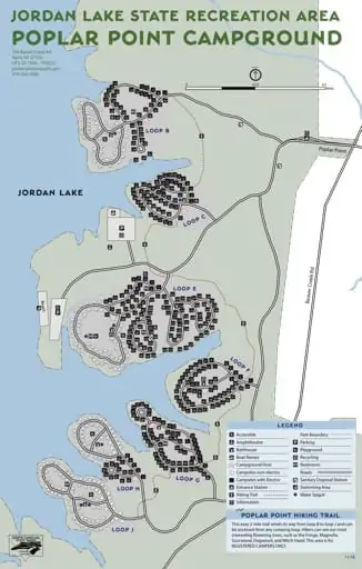
Map of Poplar Point Campground in Jordan Lake State Recreation Area (SRA) in North Carolina. Published by North Carolina State Parks.
featured in
 | North Carolina Pocket Maps |
558 Beaver Creek Rd
Apex, NC 27502
GPS: 35.7420, -79.0021
jordan.lake@ncparks.gov
919-362-0586
1
North
11
15
36
13
14
16
17
18
20
21
37
19
35
39
40
34
44
45
46
47
49
30
27
29
48
82
67
58
81
64
63
61
57
Poplar Point
78
65
56
55
83
77
66
68
84
76
69
53
88
85
75
71
70
50
54
73
72
51
94
90
86
74
28
52
1
2
92
87
25
80
79
62
60
59
14 12 10 8
15
16
35 34
37
13
17
33
11 9
19
7
6
4
5
20
3
21
18
41 36
31
29
22
32
42
27
40
30
43
25
28
44
48
26
45
49
24 23
46
52
58
54
56
47
50
57
51
53 55
38
39
5
6
8
11
10
Beach
23
25
22
24
26
18
20
28
12
13
16
71
19
72
27
14
15
17
74
70
73
30
29
33
31
34
67
66
32
63
36
39
37
42
45 47
48
49
41
43
52
46
44
117
133
119
103
141
120 122
124
54
19
21
20
23
25
26
16
30
11
42
45
43
34
27
25
39
40
21
22
38
37
41
42
44
19
43
47
20
18 17
16
48
46
45
54
59
23
24
36
56
55
49
13
54
15
11
62
12
10
9
8
7
53
52
61
3
2
52
63
64
1
4
30
32 31
23 24 25
26
16
27
48
2
3
29
1
60
28
50
52
49 51
54
53
56
55
58
59
61
57
14 12
15 13
11
43
42
39
40
Accessible
Park Boundary
Amphitheatre
Parking
Bathhouse
Playground
Boat Ramps
Recycling
88
Campground Host
Restrooms
1
Campsites non-electric
Roads
Campsites with Electric
Sanitary Disposal Station
Entrance Station
Swimming Area
Hiking Trail
Water Spigot
10
9
8
7
6
41
5
3
4
2
58
60
62
57
59
61 63 64
1
65
66
5
3
64
63
65
29
5
16
18
20
6
7
10
13
4
59
62
18 17
48
50
52
47
54 56
49
51
53
55
4
8
9
Information
6
51
58
60
53
60 61
14
50
57
51
56 55
58
21
20
19
46
5
50
49
57
26
6
7
46
47 48
30 29
28
8
9
44
33 34
33
10
41
31
31
13
12
35
40
32
35
36
39
144
38
35
39
36
46
42
43
37
40
41 44 45 47
33
34
31
44
37
32
45
35
38
36
14
38
29
30
15
37
28
27
32
17
25
26
27 28
18
14
17
19
33
23 22
11
12
15
51 53
34
22
143
99 100
98
24
147
145
126
55
50
148
146
127
96 97
21
22
24
142
128
129
149
151
140
131
125
123
101
139
132 138
130
150
153
121
102
104
152
137
134
116
118
105
95
56
57
115
106
92
94
58
59
40
108
154
136 156
135
107
84
90
93
60
61
114
87
91
62
38
35
83
155
160 159 158 157
113
109
85
89
64
82
88
65
81
161
111 112
110
78
86
68
1
80
76
75
69
3
2
79
77
2
1
4
7
9
21
0.5
Miles
93
89
24
0.25
6
91
26
31
9 8
23
22
32
43
4
3
33
42
41
10
0
5
Beaver C
reek Rd
38
7
12
66
67
74
69
71
75
73
68
70
72
2
1
This easy 2 mile trail winds its way from loop B to loop J and can
be accessed from any camping loop. Hikers can see our most
interesting flowering trees, such as the Fringe, Magnolia,
Sourwood, Dogwood, and Witch Hazel. This area is for
REGISTERED CAMPERS ONLY.
11/16


