 | Boise - Mountain HomeNational Forest - Idaho |
featured in
 | Idaho Pocket Maps | |
 | National Forests Northwest |
location
maps

Map of Boise National Forest in the USFS Intermountain Region 4 in Idaho. Published by the U.S. Forest Service (USFS).

1:100K map of Mountain Home in Idaho. Published by the U.S. Forest Service (USFS).

1:100K map of Fairfield in Idaho. Published by the U.S. Forest Service (USFS).

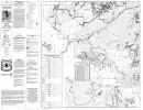
Map of the Mountain Home Ranger District of Boise National Forest in the USFS Intermountain Region 4 in Idaho. Published by the U.S. Forest Service (USFS).

Map of the Southern part of the BLM Boise District in Idaho. Published by the Bureau of Land Management (BLM).

Map of the Central part of the BLM Boise District in Idaho. Published by the Bureau of Land Management (BLM).

Trails Map of Rainbow Basin Area in Mountain Home Ranger District in Boise National Forest (NF) in Idaho. Published by the U.S. Forest Service (USFS).

Map of Mountain Home Ranger District Trails in Boise National Forest (NF) in Idaho. Published by the U.S. Forest Service (USFS).

Map of Idaho City Ranger District Trails in Boise National Forest (NF) in Idaho. Published by the U.S. Forest Service (USFS).

Motor Vehicle Use Map (MVUM) of the eastern Idaho City Ranger District in Boise National Forest (NF) in Idaho. Published by the U.S. Forest Service (USFS).

Motor Vehicle Use Map (MVUM) of the western Idaho City Ranger District in Boise National Forest (NF) in Idaho. Published by the U.S. Forest Service (USFS).

Motor Vehicle Use Map (MVUM) of the eastern Mountain Home Ranger District in Boise National Forest (NF) in Idaho. Published by the U.S. Forest Service (USFS).
Motor Vehicle Use Map (MVUM) of the western Mountain Home Ranger District in Boise National Forest (NF) in Idaho. Published by the U.S. Forest Service (USFS).


