 | Trail MapRed Top Mountain |
Trail map for Red Top Mountain State Park (SP) in Georgia. Published by Georgia State Parks & Historic Sites.
featured in
 | Georgia Pocket Maps |
Red Top Mountain State Park Trail Map
17
3
1
P a rk
Mari
oad
Red Top
Mountain
#2
Lo d
g
Ro
ad
AH
OW
Roa
d Top
Re
Rd
.
d
Top
ain
unt
Mo
a
Ro
Mo
untain
500 1,000
Exit 278
Glade Rd.
d
R
ad
Ro
Feet
2,000
Entrance #2
R
e
di
an
Log Cabin
Boat
Dock
ry
er
Top
0
VE
r ina Road
Ma
Park
Re
ed
RI
Cottage Road
ET
2
#1
#4
na R
7
5
Park Marina –
Boat Rentals
15
9
6
4
#5
B
e
ac
h
Bethany
Cem.
te
Ga
Wheelchair Access
Tennis
Miniature Golf
Webster ’
s F
50 Lodge Road, S.E. • Acworth, GA 30102 • park: 770-975-0055 • reservations: 1-800-864-7275 • GeorgiaStateParks.org
18
13
11
8
#6
#3
Picnic Shelter
Group Shelter
Cottage
Campground
Pioneer Camping Area
Boat Ramp
Beach
ng
14
12
10
#2
Iron Hill
Park Office
Parking
Phone
Restrooms
Visitor Center
Picnic Area
L
16
#7
#1
Unpaved Road
Paved Road
White Tail Trail
Visitor Center Loop Trail
Sweet Gum Trail
Lakeside Trail
Iron Hill Trail
Homestead Trail
Campground Trail
Allatoona
Lake
I-75
To rsville
te
Car 6 mi.
Entrance
#1
Do
ck
d
Safety Tips & Etiquette
• Tell someone your itinerary and expected return
time.
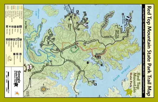
Red Top Mountain State Park is a very popular park
located on 12,000-acre Lake Allatoona and is ideal
for swimming, boating and fishing. Visitors can bring
their own boats or rent from nearby marinas. More
than 15 miles of hiking trails wind through the park,
providing opportunities for exercise and exploring
a reconstructed 1860s homestead. A 0.75-mile
paved trail behind the Park Office is suitable for
wheelchairs and strollers, and the new 3.9-mile Iron
Hill Trail is open to both hikers and bikers. Named
for the soil’s rich red color caused by high iron-ore
content, Red Top Mountain was once an important
mining area for iron.
• Be prepared for unexpected weather changes by
dressing in layers and carrying rain gear.
HOMESTEAD TRAIL (counter-clockwise)
1050
1000
950
900
850
0
2
Miles
3
4
1100
Visitor Center Loop Trail
1050
This beautiful trail begins one hundred yards down
the beginning of the Sweet Gum Trail from the Visitor
Center parking area. The Sweet Gum Trail will bear
sharp left and the Visitor Center Loop will bear sharp
right. Shaded hardwood forest, a small spring fed
stream, and two viewing/relaxation platforms can be
enjoyed. Trail is blazed green and is not accessible
to bicycles.
1000
950
900
850
0
0.75
Miles
0.75 mile loop | Compacted Soil Surface | Moderate
LODGE LOOP TRAIL (counter-clockwise)
1100
Lakeside Trail
1100
1050
1050
1000
1000
950
950
900
900
0
1
Miles
2
3
850
3.9 mile loop | Gravel Surface | Moderate
0
0.75
Miles
0.75 mile loop | Paved Surface | Easy
White Tail Trail
This trail begins at the Park Office parking area and
shares a trailhead with the Sweet Gum Trail. The Whitetail
Trail then turns off the Sweet Gum Trail and runs north to
the end of a scenic point at the edge of Lake Allatoona.
WHITE TAIL TRAIL
SWEETGUM LODGE LOOP TRAIL (counter-clockwise)
1100
1050
1000
1100
950
1050
900
1000
850
950
0
Miles
1
3.5 mile loop | Compacted Soil Surface | Moderate
900
0
Miles
This trail begins at the front porch of the park Visitor
Center, turns north for one mile, crosses Lodge Road
and then makes a 3.5 mile loop through some of the
most beautiful areas of the park. The loop portion
follows the lakeshore for approximately half its
length. Completion of the loop brings the hiker back
to the same one mile route to the front porch. This
trail is named after one of several homesteads which
were once located in the loop portion. Trail is blazed
yellow and is not accessible to bicycles.
VISITOR CENTER LOOP TRAIL (counter-clockwise)
The parking lot for this trail is located off Red Top
Mountain Road, on the right a half mile past the
campground. It is a graveled trail that is accessible to
both hikers and bicycles. From the parking lot, follow
the directional signs to the trailhead. This scenic
trail is a loop that winds along the banks of the lake
through a historic area that was once home to an
active iron mining community in the mid 1800s. Along
the way you will have the opportunity to observe both
native
wildlife and a profusion of native plants.
IRON HILL BIKE TRAIL
850
1
5.5 mile loop | Compacted Soil Surface | Moderate
Iron Hill Bike Trail
850
Homestead Trail
1100
0.5
0.5 mile, one way | Compacted Soil Surface | Moderate
This short paved trail starts at the Park Office
parking lot and makes a loop around on the shore
of Lake Allatoona. It is ADA accessible trail for the
entire length. A focal point is the 1869 Vaughan cabin
located right along the trail. Visitors enjoy special
programs held at the cabin as well as relaxing on
the benches along the trail and shoreline. Trail is not
blazed and no bicycles are allowed.
• Take a map, water, snacks, first aid kit, flashlight
and whistle. Three short blasts on a whistle are
known as a call for help.
• Do not stray from trails. If you become lost, stay
in one location and wait for help. This will make it
easier for rescuers to find you.
• Don’t count on cell phones to work in the
wilderness, but if they do, be able to give details
about your location.
• Invest in good hiking socks such as those found at
sporting goods stores. Avoid blisters by carrying
“moleskin” and applying it as soon as you feel a
hot spot on your feet. Available in the foot care
section of drug stores, moleskin is like felt that
sticks to your skin.
• Be prepared for unexpected rain and wind which
can lead to hypothermia. Always carry quality rain
gear and turn back in bad weather. If you become
wet or cold, it is important to get dry and warm as
quickly as possible.
• Dress in layers and avoid cotton. Luckily, today’s
hikers can choose from numerous fabrics that
wick moisture, dry quickly or conserve heat. Many
experienced hikers wear a lightweight shirt that
wicks moisture, while carrying a fleece pullover
and rain jacket.
• Pack out all trash.
• Keep pets on a leash at all times. This is strictly
enforced. Maximum leash length is 6 feet.
• Do not pick flowers or disturb wildlife.
• Protect the landscape by staying on trails.
• Alcohol is prohibited in public areas of the park.
• A Georgia ParkPass is required to be displayed
in your vehicle. Passes are available at all major
parking lots and inside the Park Office & Visitor
Center.
Climate Data for Acworth, GA
Sweetgum Trail
This trail begins at the Visitor Center parking area
and also follows a route north. After 0.5 mile the trail
then makes a loop through the Park Office area of
the park and then back to the 0.5 mile section for a
return to the Visitor Center. The Sweet Gum Trail also
travels south from the Visitor Center and connects
to the Campground Trail which connects to the
campground, allowing campers to access the park
trail without driving. There are sections of the trail
where Homestead and Sweet Gum share the same
pathway. These sections are marked with yellow and
red blazes. Trail is not accessible to bicycles.
Month
Avg.
High
Avg.
Low Mean
Avg.
Precip.
Record High
Record Low
Jan
Feb
Mar
Apr
May
Jun
Jul
Aug
Sep
Oct
Nov
Dec
50ºF
55ºF
64ºF
72ºF
78ºF
85ºF
89ºF
88ºF
82ºF
72ºF
62ºF
53ºF
30ºF
32ºF
38ºF
45ºF
55ºF
63ºF
67ºF
66ºF
60ºF
47ºF
39ºF
33ºF
4.00 in
4.30 in
5.23 in
4.07 in
3.27 in
3.57 in
3.62 in
3.05 in
3.27 in
2.55 in
3.69 in
3.84 in
-9ºF(1985)
1ºF (1996)
8ºF (1960)
22ºF (1987)
31ºF (1961)
40ºF (1966)
49ºF (1967)
48ºF (1964)
30ºF (1967)
23ºF (1961)
4ºF (1950)
-3ºF (1983)
40ºF
44ºF
51ºF
58ºF
66ºF
74ºF
78ºF
77ºF
71ºF
60ºF
51ºF
43ºF
79ºF (2002)
83ºF (1977)
87ºF (2002)
93ºF (1986)
98ºF (1962)
105ºF (1954)
106ºF (1954)
108ºF (1954)
106ºF (1954)
100ºF (1954)
87ºF (1961)
81ºF (1956)


