Mission Peak

Regional Preserve - California

Mission Peak Regional Preserve is a public park east of Fremont, California, operated by the East Bay Regional Park District. It is the northern summit on a ridge that includes Mount Allison and Monument Peak. Mission Peak has symbolic importance, and is depicted on the logo of the City of Fremont. This park borders and overlooks Silicon Valley, and is popular with local hikers, bicyclists, sightseers from the Bay Area, and tourists from beyond for its vista and strenuous climb. The "Mission Peeker" marker pole at the summit is the most famous and geo-tagged landmark in the City of Fremont. The Stanford Avenue entrance receives up to two thousand visitors per day on weekends.

location

maps

Map of Alviso Marina County Park (CP) in Santa Clara County in California. Published by Santa Clara County Parks.Santa Clara - Alviso Marina

Map of Alviso Marina County Park (CP) in Santa Clara County in California. Published by Santa Clara County Parks.

Trails Map of the Alviso Slough Trail in Alviso Marina County Park in Santa Clara County in California. Published by Santa Clara County Parks.Alviso Marina - Alviso Slough Trail

Trails Map of the Alviso Slough Trail in Alviso Marina County Park in Santa Clara County in California. Published by Santa Clara County Parks.

Ward Map of the East Bay Regional Park District in California. Published by the East Bay Regional Park District.East Bay Regional Parks - Ward Map

Ward Map of the East Bay Regional Park District in California. Published by the East Bay Regional Park District.

Vintage 1947 USGS 1:250000 Map of San Jose in California. Published by the U.S. Geological Survey (USGS).Vintage USGS - San Jose - 1947

Vintage 1947 USGS 1:250000 Map of San Jose in California. Published by the U.S. Geological Survey (USGS).

Vintage 1957 USGS 1:250000 Map of San Francisco in California. Published by the U.S. Geological Survey (USGS).Vintage USGS - San Francisco - 1957

Vintage 1957 USGS 1:250000 Map of San Francisco in California. Published by the U.S. Geological Survey (USGS).

brochures

Brochure of Mission Peak Regional Preserve, part of East Bay Regional Park District. Published by East Bay Regional Park District.Mission Peak - Brochure

Brochure of Mission Peak Regional Preserve, part of East Bay Regional Park District. Published by East Bay Regional Park District.

A photographic guide to showy wildflowers of Mission Peak Regional Preserve, part of East Bay Regional Park District. Published by East Bay Regional Park District.Mission Peak - Wildflowers

A photographic guide to showy wildflowers of Mission Peak Regional Preserve, part of East Bay Regional Park District. Published by East Bay Regional Park District.

Wild Plants of Mission Peak Regional Preserve, part of East Bay Regional Park District. Published by East Bay Regional Park District.Mission Peak - Wild Plants

Wild Plants of Mission Peak Regional Preserve, part of East Bay Regional Park District. Published by East Bay Regional Park District.

Mission Peak RPres https://www.ebparks.org/parks/mission/ https://en.wikipedia.org/wiki/Mission_Peak Mission Peak Regional Preserve is a public park east of Fremont, California, operated by the East Bay Regional Park District. It is the northern summit on a ridge that includes Mount Allison and Monument Peak. Mission Peak has symbolic importance, and is depicted on the logo of the City of Fremont. This park borders and overlooks Silicon Valley, and is popular with local hikers, bicyclists, sightseers from the Bay Area, and tourists from beyond for its vista and strenuous climb. The "Mission Peeker" marker pole at the summit is the most famous and geo-tagged landmark in the City of Fremont. The Stanford Avenue entrance receives up to two thousand visitors per day on weekends.
Mission Peak R GARIN AV. D. LR HIL FOOT Pleasanton Ridge Dry Creek/ Pioneer S TO DECO TO R D. UNION CITY VA ST EV EN SO N MO W AV RY . 880 ISS IO N BL VD . ROAD ERAS . BL 680 L CRE MIL EK RD. NEWARK M CALAV Vargas Plateau AS RG VA RD. Historic Farm 84 AD RO NILES CANYON RD. S RD . Quarry PAS EO Lakes EM D ON RE T PK Ardenwood BL. WY FR CI LLE SUNOL NILE 84 SANTA LIVERMORE RITA D ROA HO VALLEY AV. Shadow VD. STANLEY BL Cliffs PY AR D RD . PLEASANTON VIN EYA BER RD NAL AV. AV. Garin Reg. Park PA BICYCLE POLICY Safe multiple use on these trails requires your cooperation. The East Bay Regional Park District’s Bicycle Ordinance is summarized below: • Bicycles shall not be ridden in a negligent, unsafe, or reckless manner, or in a way that endangers the life, limb, or property of any person. • Bicycles are permitted on paved roads, paved bike trails, and unpaved roads over 8 feet in width, unless otherwise posted. • Bicycles are not permitted to ride cross country on Regional Parklands. All bicycles use is restricted to permitted trails only. • Bicycles shall not be ridden at a speed exceeding 15 miles per hour on any trail with a posted speed limit. • Bicycles shall not be ridden at excessive speeds, especially when passing other trail users or in areas with short sight distances, or in an irresponsible manner in violation of published trail etiquette or posted bicycle speed limits. • Bicycles must travel in single file on the right side of the trail when on turns or blind corners. • Bicycles are not permitted in any park or area posted pursuant to a resolution of closure or restriction adopted by the Park District Board of Directors. OA D . VD BL POLICE, FIRE, MEDICAL EMERGENCY.................................9-1-1 EBRPD HEADQUARTERS......................................1-888-327-2757 PARK OFFICE........................1-888-327-2757, option 3, ext. 4545 FIRE HAZARD PARK CLOSURE ............................510-544-2222 INTERPRETIVE HIKES The interpretive staff at Coyote Hills Regional Park plans organized hikes along the slopes and the peak. For more information, call (510) 544-3220, or see www.ebparks.org. 580 Palomares PA Ridge L N IO ISS M “Perhaps the denizens of this valley are so accustomed to the sight of Mission Peak that they fail to appreciate the dignity and individuality which it gives to the landscape. Whether the outlines, snow-capped may be, are sharp and distinct on a clear, frosty morning in winter, or overspread with the purple afterglow of a summer sunset; whether rising grim and rugged against black storm clouds, or emerging into sunlight from unwinding fog wreaths, the mountain has a majesty of its own... “It is a singular fact that many living in the township, even some born and reared here, have never ascended this mountain. They have gone to Tamalpais, tramped to Diablo, and to other mountains farther off, ignorant of the vast and wonderful landscape to be seen from their own. Standing on the top, when the day is clear, we can see far in the east the shining summits of the high Sierra...Spread out between is the great plain of the San Joaquin, and the smaller valleys of San Ramon, Livermore and Sunol. The canyon immediately in front drops down 2,000 feet into Rosedale, and on the other side are the serrated crags of the Calaveras. Far and faint in the south is the huge bulk of the Gabilans, while nearer is flat-topped Loma Prieta, and closer still the silver dome and clustered dwelling of Lick Observatory, with the higher top of Mount Hamilton behind. Due north rise the splendid double peaks of Mount Diablo, the giant of the Coast Range.” (Excerpted from History of Washington Township,1904, Stanford University Press.) 
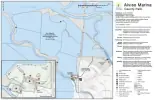
TODAY Mission Peak trails begin at Fremont’s Ohlone College campus and at the east end of Stanford Avenue off Mission Boulevard. The Bay Area Ridge Trail passes through the park into Santa Clara County’s Ed Levin County Park. Mission Peak’s panorama includes the southern arm of San Francisco Bay and the area from San Jose to Mount Tamalpais. To the north can be seen Mount Diablo, the San Ramon Valley, and the Hamilton Range. Coyote Hills Regional Park is visible to the west by the Dumbarton Bridge, and eastward is Sunol Regional Wilderness. No drinking water is available along the trails. Wear sturdy hiking shoes. Keep the area free of litter so others may enjoy the beauty as you do. The Wings of Rogallo has an agreement with the Park District to conduct hang gliding and paragliding activities at the Preserve, so while at the peak, don’t be surprised if a quiet hang glider whisks ’round the peak or overhead. You can wave to the pilot – at eye level. The South Bay Soaring Society (SBSS) has an agreement with the Park District to use R/C Hill to fly remote-controlled aircraft. No motorized or gaspowered aircraft are allowed. All remote-controlled pilots launching at R/C Hill must be members of SBSS and must have in their posses
Mission Peak Wildflowers A photographic guide to showy wildflowers of Mission Peak Regional Preserve Sorted by Flower Color Photographs by Wilde Legard Botanist, East Bay Regional Park District Revision: February 23, 2007 More than 2,000 species of native and naturalized plants grow wild in the San Francisco Bay Area. Most are very difficult to identify without the help of good illustrations. This is designed to be a simple, color photo guide to help you identify some of these plants. The selection of showy wildflowers displayed in this guide is by no means complete. The intent is to expand the quality and quantity of photos over time. The revision date is shown on the cover and on the header of each photo page. A comprehensive plant list for this area (including the many species not found in this publication) can be downloaded at the East Bay Regional Park District’s wild plant download page at: http://www.ebparks.org. This guide is published electronically in Adobe Acrobat® format to accommodate these planned updates. You have permission to freely download and distribute, and print this pdf for individual use. You are not allowed to sell the electronic or printed versions. In this version of the guide, only showy wildflowers are included. These wildflowers are sorted first by flower color, then by plant family (similar flower types), and finally by scientific name within each family. Under each photograph are four lines of information, based on the current standard wild plant reference for California: The Jepson Manual: Higher Plants of California, 1993. Common Name These non-standard names are based on Jepson and other local references. Scientific Name Scientific names revised since 1993 are NOT included in this edition. Origin & Longevity Native or Introduced. Annual, Biennial, Perennial, or a combination. Family Name The common plant family name according to Jepson. For readers that prefer a more comprehensive guide, sorted by scientific name, please download the “wild plants” version of this guide. Readers are encouraged to email any suggestions or corrections to wlegard@ebparks.org. All photographs are © 2006 Wilde Legard, all rights reserved. revision 2/23/2007 Wildflowers of Mission Peak Regional Preserve White Valley Popcorn Flower Plagiobothrys canescens Native Annual Borage Family California Buckeye Aesculus californica Native Perennial Buckeye Family Poison Hemlock Conium maculatum Introduced Biennial Carrot Family Cow Parsnip Heracleum lanatum Native Perennial Carrot Family Shepherd's Needle Scandix pecten-veneris Introduced Annual Carrot Family Canyon Gooseberry Ribes menziesii Native Perennial Gooseberry Family Common / California Manroot Marah fabaceus Native Perennial Gourd Family Blue Elderberry Sambucus mexicana Native Perennial Honeysuckle Family Page 1 of 13 revision 2/23/2007 Wildflowers of Mission Peak Regional Preserve White Page 2 of 13 Common Soap Plant Chlorogalum pomeridianum var. pomeridianum Native Perennial Lily Family Shortstem Morning Glory Calystegia subacaulis ssp. subacaulis Native Perennial Morning-Glory Family Milkmaids Cardamine californica Native Perennial Mustard Family White Water Cress Rorippa nasturtium-aquaticum Native Perennial Mustard Family Subterranean Clover Trifolium subterraneum Introduced Annual Pea Family Bicolor Linanthus Linanthus bicolor Native Annual Phlox Family Mouse-ear Chickweed Cerastium glomeratum Introduced Annual Pink Family Windmill Pink Silene gallica Introduced Annual Pink Family revision 2/23/2007 Wildflowers of Mission Peak Regional Preserve White Page 3 of 13 Common Chickweed Stellaria media Introduced Annual Pink Family Creambush / Ocean Spray Holodiscus discolor Native Perennial Rose Family Western Chokecherry Prunus virginiana var. demissa Native Perennial Rose Family Native California Blackberry Rubus ursinus Native Perennial Rose Family Woodland Star Lithophragma affine Native Perennial Saxifrage Family California Saxifrage Saxifraga californica Native Perennial Saxifrage Family Yarrow Achillea millefolium Native Perennial Sunflower Family Blow Wives Achyrachaena mollis Native Annual Sunflower Family revision 2/23/2007 Variable-leaf Nemophila Nemophila heterophylla Native Annual Waterleaf Family Wildflowers of Mission Peak Regional Preserve Wild Heliotrope Phacelia Phacelia distans Native Annual Waterleaf Family White Page 4 of 13 revision 2/23/2007 Wildflowers of Mission Peak Regional Preserve Yellow Common Fiddleneck Amsinckia menziesii var. intermedia Native Annual Borage Family California Buttercup Ranunculus californicus Native Perennial Buttercup Family Pacific Woodland Sanicle Sanicula crassicaulis Native Perennial Carrot Family Erect-pod Winter Cress Barbarea orthoceras Native Perennial Mustard Family Black Mustard Brassica nigra Introduced Annual Mustard Family Yellow Charlock Sinapis arvensis Introduced Annual Mustard Family Bermuda Buttercup Oxalis pes-c
Wild Plants of Mission Peak Regional Preserve Common Name Version A Photographic Guide Sorted by Form, Color and Family with Habitat Descriptions and Identification Notes Photographs and text by Wilde Legard District Botanist, East Bay Regional Park District New Revised and Expanded Edition - Includes the latest scientific names, habitat descriptions and identification notes Decimal Inches .1 .2 .3 .4 1/8 1/4 .5 .6 1/2 .7 .8 .9 3/4 1 .5 2 .5 3 .5 4 .5 5 .5 6 .5 7 .5 8 .5 9 1 1/2 2 1/2 3 1/2 4 1/2 5 1/2 6 1/2 7 1/2 8 1/2 9 English Inches Notes: A Photographic Guide to the Wild Plants of Mission Peak Regional Preserve More than 2,000 species of native and naturalized plants grow wild in the San Francisco Bay Area. Most are very difficult to identify without the help of good illustrations. This is designed to be a simple, color photo guide to help you identify some of these plants. This guide is published electronically in Adobe Acrobat® format so that it can easily be updated as additional photographs become available. You have permission to freely download, distribute and print this guide for individual use. Photographs are © 2014 Wilde Legard, all rights reserved. In this guide, the included plants are sorted first by form (Ferns & Fern-like, Grasses & Grass-like, Herbaceous, Woody), then by most common flower color, and finally by similar looking flowers (grouped by genus within each family). Each photograph has the following information, separated by '-': COMMON NAME (Scientific Name) Origin & Longevity Family Name (Bloom date range) Habitat ID Characteristics Additional notes Revision: 3/2/2014 According to The Jepson Manual: Vascular Plants of California, Second Edition (JM2) and other references (not standardized). According to JM2 and eFlora (ucjeps.berkeley.edu/IJM.html). Native, Naturalized, or Waif (not reproducing without human care). Annual, Biennial, Perennial, or a combination. Common family name according to JM2, Period during the year when the plant blooms, according to JM2 and other sources. '-' if plant does not bloom (ie. Ferns). Habitat description according to JM2 and other sources. Plant description with identification characteristics and other notes, based on multiple sources including: Annotated Checklist of the East Bay Flora, Second Edition (2013), JM2, Plants of the San Francisco Bay Region (Revised Edition), and Weeds of California and Other Western States. Occasionally, an additional note may appear (ie. NOXIOUS weed, INVASIVE weed, Fed & Calif. ENDANGERED, etc.). Fern-like - Green/Brown BRACKEN FERN (Pteridium aquilinum var. pubescens) Native Perennial - Bracken Family - - Pastures, woodland, meadows, hillsides, partial to full sun - Leaf blades widely-triangular, gen 0.5-5' long, gen 3x divided, hairy underneath. Wild Plants of Mission Peak Regional Preserve - Sorted by Form, Color and Family GOLDENBACK FERN (Pentagramma triangularis subsp. triangularis) Native Perennial - Brake Fern Family - - - Gen shaded, sometimes rocky or wooded areas - Leaves triangular, 1.2-4" long, undersides either granular green or powdery gold. SMOOTH SCOURING RUSH (Equisetum laevigatum) Native Perennial - Horsetail Family - - Moist, sandy or gravelly areas - Stems 1 kind only, 12-71" tall, unbranched. Sheath w/dark band only at the top. Page 1 POLYPODY FERN (Polypodium calirhiza) Native Perennial - Polypody Family - - - On plants, rocky cliffs or outcrops, roadcuts, often granitic or volcanic, rarely dunes - Leaf blades 4-8" long, often widest above base, deeply lobed. Revision: 3/2/2014 Fern-like - Green/Brown Wild Plants of Mission Peak Regional Preserve - Sorted by Form, Color and Family Page 2 COASTAL WOOD FERN (Dryopteris arguta) Native Perennial - Wood Fern Family - - - Locally common. Open, wooded slopes, caves - Leaf 12-24” long,5-12” wide, divided 1-2 times. Segments generally with spine-tipped teeth. SILVER HAIR GRASS (Aira caryophyllea) Naturalized Annual - Grass Family - (Apr–Jun) Sandy soils, open or disturbed sites - Flower cluster > 0.6" wide, diffuse with long slender branches. Spikelets about 0.1" long with 2 extended awns. SLENDER WILD OAT (Avena barbata) Naturalized Annual - Grass Family - (Mar–Jun) Disturbed sites - Plants gen 24-32". Spikelets 0.8-1.2" long. Awns 0.8-1.8" long. Lemma tip bristles >= 0.1" long. Seeds EDIBLE whole or ground for flour. INVASIVE weed. LITTLE QUAKING GRASS (Briza minor) Naturalized Annual - Grass Family - (Apr–Jul) Shaded or moist, open sites - Stem 3-20” tall. Spikelets 0.1-0.2” long, resemble tiny rattlesnake rattles. CALIFORNIA BROME (Bromus carinatus var. carinatus) Native Perennial - Grass Family (Apr–Aug) - Coastal prairies, openings in chaparral, plains, open oak and pine woodland -Plant 20-40” tall. Flower cluster 6-16” long. Spikelet 0.8-1.6” long. Lemma 0.5-0.8” long, hairy, awn 0.3-0.6” long. RIPGUT GRASS (Bromus diandrus) Naturalized Annual - Grass Family - (Apr–Jul) - Open

also available

National Parks
USFS NW
Alaska
Arizona
California
Colorado
Florida
Georgia
Hawaii
Idaho
Minnesota
Montana
Nevada
New Mexico
North Carolina
Oregon
Pennsylvania
Texas
Utah
Virginia
Washington
Wyoming
Lake Tahoe - COMING SOON! 🎈
Yellowstone
Yosemite